GIS - standards in CEN and ISO
Prof.ir. Henri J.G.L. Aalders
Delft University of Technology
Faculty of Geodetic Engineering
Thijsseweg 11, P.O.B. 5030, 2600 GA Delft
E-mail: h.aalders@geo.tudelft.nl
Katholieke Universiteit Leuven
Faculty of Engineering
Introduction
Standardisation is old as mankind. In communication between people gestures and signs were the first implied standards. Later when language developed the grammar rules can be understood as standards since grammar has to be followed for a correct use when speaking or writing in any language. In the use of language people agree in their own free will. These are two important aspects of standardisation: consensus and voluntariness.
Language is not only a subject for standardisation but also a means: standards are written down in documents, e.g. GIS object classification requires a well-defined semantic definition. Examples of standards can be found in ancient building and constructions, e.g. the Egyptians (1500 BC) paved the corridors in their houses by tiles with a fixed format and the Phoenicians (1000 BC) built ships of fixed sizes; in Europe Charles V (750) introduced a standardised handwriting (i.e. the Carolinian script, similar to the contemporary block letters). A main example is the definition of a useful unit of length which has been a topic of debate throughout centuries. The replacement of the many existing units of length in different European countries by the meter is one of the greatest successes of standardisation.
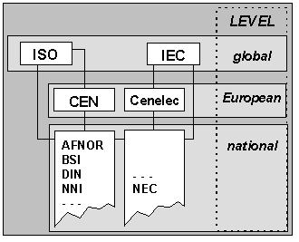 |
| Fig. 3.1 Standardisation institutes. |
The industrial revolution of the last centuries introduced an increase of scale requiring standardisation for technological and political developments. This standardisation was beyond applications and country boundaries. Around 1900 the technical standardisation became into development (e.g. BSI 1901) and nowadays almost all European countries have national standardisation institutes and eighteen of them are members of the CEN (Comité Européen de Normalization, Brussels in Belgium) i.e. Austria, Belgium, Denmark, Finland, France, Germany, Greece, Iceland, Ireland, Italy, Luxembourg, The Netherlands, Norway, Portugal, Spain, Sweden, Switzerland and the United Kingdom. The EC council decided in 1986 (decision 87/95/EC) on the application of European standards at international level.
Globally there exists the ISO (International Standard Organisation, Geneva in Switzerland). For the standardisation for Electronics and Telecommunications there exist a separate network of standardisation institutes (see fig.1).
Within a country, standardisation is applied at three levels and for each level more detailed standards should be developed:
- general level (possibly national level);
- branch level;
- application level.
Standardisation, aim and definition
Some of the aims for standardisation are (including the indications to GIS/LIS relevance):
- quality improvement. Many data in GIS are of different homogeneity. In order to improve the intrinsic relative quality clear and well defined quality concepts should be defined;
- efficiency. Standards will lead to the improvement of the data transfer avoiding duplication of data capture and processing;
- to avoid information loss. Common standards will avoid the loss of information that occurs when transforming data from one system into another;
- knowledge transfer. Standards contribute to clarify the different aspects of all applications concerned. Users will understand their mutual requirements better when transforming from one to another system.
Standardisation is a general term used for many different aspects and in many different processes i.e. classification, data transfer, data exchange, inter-connection between systems, etc. In this paper the terms standardisation and standards are used as indicated in table 1.
Though only standardisation and standards are used in English, in other languages norms and normalisation are frequently used as synonyms, although they may describe different concepts. Whenever both words occur in a language, the word standard has usually a wider meaning:
- norms (and normalisation, as the process to produce norms) is used for the official defined agreements that are applied, while
- standards (and standardisation, as the process to produce standards) is used for all type of agreements between users for mutual data transfer [4].So, the application of standards requires a complete acceptance and free agreement of the standard by both the supplier and the receiver of data in order the ease the transfer of information between them and to improve the quality and safety of the transfer.
Since standardisation is of mutual interest for both recipient and sender of data it becomes more complicated when a central data base is used by many different users in a country. Then standardisation is of interest for the whole GIS-community. If border crossing data flow exists standardisation becomes of even wider interest.
| standardisation is the process to obtain and apply a set of rules and agreements with as many potential users as possible in order to create clarity and unity in areas where diversity is unwanted |
| standards are documented (technical and procedural) agreements that are agreed upon by the (potential) users |
Table 1. Definitions of standard(isation).
Another problem in terms is the use of the words data exchange and data transfer. In general data exchange should be avoided: data goes from one user to another (transfer) and no data returns back from the recipient to the original sender. So usually nothing is exchanged but only transferred; in cases where exchange of data does really take place, i.e. data goes from sender to recipient and the recipient sends (even if it is the same) data in return one may also speak about a bi-directional data transfer.
It is difficult to determine the best moment introducing a standard. Obviously standards are required whenever user(s) have a need for it. But at the time that parties involved feel the need to introduce a standard in their application, they have undergone such a high level of development that the implementation of a new standard will create a fall-back in application or at least will be experienced as annoying to an experienced user, while a new user will not easily understand why standards should be developed let alone be applied. However, one should always realise that standards will create many new possibilities seen from a more general point of view in the arena of geo-information.
Besides, in the field of IT, standards have been applied very successfully, including graphics standards which are also of great importance to the field of GIS: many systems use PHIGS, DXF, IGES, etc.
In this presentation we will discuss the standardisation of data as opposed to the standardisation of the processes. However, in many cases the standardisation of processes will reflect quality control applying the ISO 9000 series of standards for defining requirements in the different sub-processes in order to certify the quality of the end products. One should realise that no standardisation of processes can occur without the standardisation of the data. The standardisation of data is the primarily goal of the standardisation proposals of the CEN/TC 287, while the ISO/TC 211 focuses more on standardisation of processes (see fig. 2).
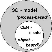
Fig. 2 Mutual relation between the standardisation of data and processes.
First some theoretical background required for the process of standardisation will be discussed, the technical aspects that are involved when developing and using standards and the political and organisational impact of standardisation within a country in relation to continental and global developments.
Being member of CEN TC/287 (Technical Committee 287 of Européen Comité de Norma-lisation on "Geographical Information") the developments within the (sub-) working groups will be presented.
Theoretical background
Geographic entities are obtained by abstracting real world objects; through pre-defined rules about what objects and attributes are to be selected, which definitions are to be used and how it should be stored and visualised (see fig. 3).
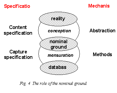
This, in fact subjective representation of the reality defines the required contents of the database: a definition of the query space for a certain application through information analysis and is called the "nominal ground" (as in French: "terrain nominale", or in the US "abstract view of the universe" or in UK "universe of discourse"). This interpretation of the reality is subjective because of:
- object type descriptions. Reality is supposed to be a set of mutual depending objects which are modelled by the description of the objects into entities, attributes and the mutual relations. These descriptions are made by a future user and as such are user-subjective;
- application dependency. Because of the application specification in defining the nominal ground only the objects of interest for a specific user will be considered, avoiding all other objects (which may be of interest for other users. But who is paying for the capture and updating of those objects? ).
This approach, when designing a database, is known as the object-based design in GIS and allows to apply all aspects that information- and database technology makes available.
Because of the specific geographical character of geographic objects their attributes should include:
- semantic attributes, representing the meaning of all objects by human interpretation;
- geometric attributes. They are the essential characteristics that distinguishes geographical objects from other database objects (though they may appear as well in raster as in vector format). Because of the k-dimensionality of geographic objects special geometrical structures have to be designed in order to allow to store in existing 1-dimensional databases. Geometric attributes indicate:
- position, in a pre-defined geodetic co-ordinate-reference-system;
- topology, to relate mutually the neighbourhood between objects;
- shape, in mathematical interpolation terms;
- graphics, the store the representation of objects by line-type and -width, point- and line-symbolic, area-patterning, colour, text-size and-style, etc.;
- descriptions by text, photographs, drawings, video and other type of pictures. These attributes are usually stored in other databases because of their different nature. The link is made by unique keys in both databases.
As in IT the values of attributes are either:
- quantitative attributes, measured and expressed in a pre-defined unit as length, temperature, time, etc., or
- qualitative attributes, where each attribute can have only one values from a pre-defined set of values as names, addresses, colours, etc. A discrete value is nominal when there is no ordering possible e.g. forest, house, red, etc. or ordinal when a (mathematical) ordering is possible e.g. house numbers in addresses or alphabetical ordering of names.
To fill the database, occurrences of entities are captured and stored, based on the :
- specification of the quality aspects;
- specification of the required quality.
Do not mix object-based database design with object-oriented database design. Besides the object-based definition in object-orientation a special (object-oriented) structure is required involving the definition of the object-oriented hierarchy, encapsulation, messages and channels, aggregation, generalisation, etc.
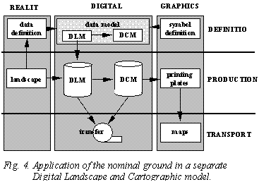
Occurrences of entities in the database can be attributed accor-ding to their properties however often also cartographic represen-tation attributes are included. Graphical definitions such as line styles, point- and line symbols, line thickness, area patterns, colour, texts are often found either as attributes or as separate mm occurrences in the data base (see fig. 4). They are mixed with the actual topographical information in order to enable to make maps out of the data base but in fact, with these cartographic symbology it is only possible to make one certain type of map (only the one that is defined in the data) from this data base.
If the data base serves a multitude of applications a clear distinction should be made between the nominal ground (i.e. the ideal set of topographical information of the terrain for all intended applications) and the graphical presentation of the nominal ground using a separate symbology catalogue for every map. The transfer standard should enable to transfer both.
GIS standards
Standardisation in GIS is a specialisation of the standardisation in IT. The special characteristics of the standardisation in GIS refer to the geometrical components of GIS objects. As in IT the GIS-standardisation requires standards for (see fig 5):
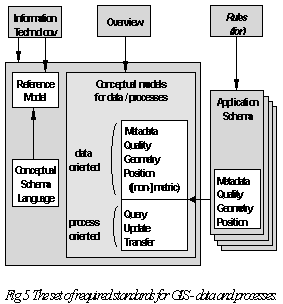
- terms used in the standards and the definition of objects (entities) and relations and their attributes;
- reference systems for position and semantics Metric position can be expressed in vector mode by geodetical point co-ordinates or in raster mode by grids, pixels, voxels through their row- and column number. From theoretical point of view the elementary differences between positional vector- and raster model refers to the implicit and explicit definitions of the entities' characteristics (see table 2);
- conceptual models, including the general level-1 IRDS-models and the sub-models for semantic definitions, geometry, quality and metadata (including quality), last three being special for GIS.
|
vector |
Raster |
| dimension |
1 - D |
2 - D |
| Explicit storage |
boundaries topology |
area |
| Implicit storage |
area |
boundaries
topology
|
Table 2. Theoretical differences between raster and vector models.
The conceptual data model defines all entity types which makes it possible to describe and position all selected phenomena and which raise the knowledge of geographical environment.
The geometry model describes the metric primitives that are used in the model as point, lines, areas, volumes, grids, pixels, voxels, frames, raster-bands, etc. as well as the topological primitive as nodes (terminating, isolated or intermediate), edges (with relations as previous/next edges, left/right hand faces) and faces (with outer ring(s) and possibly inner ring(s).
The metadata model comprises directory data, describing the data set's characteristics as, its origin, owner and manager with their addresses, coverage, security aspects, etc. and dictionary data, describing the data set's conceptual schema including the reference systems, data definition, relations, etc.
The quality model includes the parameters that may be taken into account for characterising the quality of any data (sub-)set and includes lineage, ability for abstraction, accuracy, reliability, completeness, consistency and currency:
| Institute |
Standard |
Remarks |
| CEN/TC 287
(Comité Européen de
Norma-lisation)
|
- |
In development since 1992;
|
| ISO/TC 211
(International Standardisation
Organisation)
|
- |
TC founded in April 1994;
No work done yet
|
| IHO
(International Hydrographic
Organisation)
|
SP 57
(DX 90)
|
Only for hydrographical map
applications
|
| CERCO
(Comité Européen des Responsables
de la Cartographie Officielle)
|
ETDB
(European Territorial
Data Base)
|
Development within the
MEGRIN project to link existing
and future official data sets
|
| DGWIG
(Digital Geographic Information
Working Group)
|
Digest
(DIgital Geographic
Exchange Standard)
|
For transfer of data between
national systems and an
integrated NATO- structure
|
| Drive EDRM |
GDF 2.0 |
Developed for transport/road
applications. Official pre-standard
is published in September 1994
|
Table 3. Existing international standard(-committee)s (status 1992 [3]).
- · functions and predicates for updating and querying the database;
- · data transfer format and mechanism for transferring data from one system to another. Special transfer formats require the transfer of files and records, while the logical model uses coverage, sub-coverages, levels, modules, entities, relations, attributes, etc. The general transfer mechanism contains definitions how to convert types of a logical model into a physical transfer format;
- · application schemes; each application may consists of several datasets for which the schemes should be designed in respect of metadata, semantic, geometry, quality and position reference systems;
- · overview, indicating the function and the use of the different GIS standards.
- · often digital geographic data is used for displaying in maps either on screen or on paper. In both circumstances standards for representation of objects is required forcing a standard symbology.
| Country |
Standard |
Remarks |
| Australia |
AUS-SDTS |
Based on SDTS from US |
| Based on SDTS from US |
A 2260
A 2261
|
= Transfer format
= Object Catalogue
|
| Canada |
SAIF |
Pre-norm CGSB |
| Finland |
FigDIS
(VHS- 1041)
|
Official standard named JHS 116 - 119 |
| France |
EDIGéO |
Official standard named AFNOR Z13-150 |
| Germany |
Atkis EBDS |
Only for ATKIS/ALK |
| Great Britain |
BS 7567 |
Originally NTF (1988) |
| Hungary |
DFT |
Only for cadastral applications |
| Israel |
IEF 91 |
For data capture and to promote the use
of digital data within the government
|
| Japan |
SPDFDM |
Format- and coding-system and
procedural- and quality specifications
|
| Netherlands |
NEN 1878 |
Originally SUF (1979) |
| Norway |
SOSI |
Only DLM applications |
| Russia |
DEMTS |
Comprises data capture procedures,
structure and data transfer
|
| Spain |
NICCa
NOTIGEO
|
= mandatory for cadastral applications
= for map scales 1 : 25 000 and smaller
|
| South Africa |
NES V 2.0 |
|
| Sweden |
KF 85 |
|
| Switzerland |
InterLIS |
Includes conceptual model and format |
| United States
of America
|
SDTS |
Mandatory for federal institutions |
Table 4. Existing national standards (status 1992 [3]).