Figure 1 Different cadastral maps in the Slovak Republic.
For this reason the European Union created the PHARE Programme which supports the development of a larger democratic family of nations within a prosperous and stable Europe. Its aim is to help the countries of Central and Eastern Europe rejoin the mainstream of European development and build closer political and economic ties with the European Union.
PHARE does this by providing grant finance to support the process of economic transformation and to strengthen newly created democratic societies. PHARE also provides grant finance to help countries with Europe Agreements integrate with the European Union.
In its five first years of operation to 1994, PHARE has made available 4,283 million ECU to 11 partner countries, making PHARE the largest assistance programme of its kind. The Multi Annual Programme of 1995-1999 has even a larger budget.
PHARE works in close co-operation with its partner countries to decide how funds are to be spent, within a framework agreed with the European Union. This ensures that PHARE funding is relevant to each government's own reform policies and priorities. Each country takes the responsibility for running its own programmes.
Almost all the countries in Central Europe have chosen to spend a considerable amount of their PHARE budgets to improve their land information systems. In practice this means a reconstruction/improvement of the cadastral systems and the topographic mapping systems. During the Communist period the cadastral systems became out-dated, because of the collectivisation of land and property. In the same time topographic maps and aerial photographs were not available for civil purposes, but were considered as classified information for military purposes. The reconstruction of these important elements in the land information systems is a tremendous task which will take many decades in the next century. Discussions on the introduction of a geographic information infrastructure are in my opinion only of academic value if the primary conditions of the availability of a good cadastral system and an up-to-date set of topographic (digital) maps are not fulfilled.
In this presentation I like to give information about my activities as consultant for the PHARE Programme with respect to the improvement of the land information sector in the countries of Central Europe. In this respect I have made several so-called Strategic Review Studies for the Land Information Systems. In order to make comparison between the different countries possible, the review studies are carried out along established lines. As a result of these Review Studies I am now involved in the preparation of Enhanced Cadastral Systems in different countries.
This paper is based on some chapters of the Review Studies with respect to cadastral mapping and topographic mapping in the Czech Republic, the Slovak Republic, Hungary and Poland.
The four countries of Central Europe (Poland, Czech Republic, Slovak Republic and Hungary), involved in this study, have the intention to digitise the cadastral maps. This is an enormous task. Roughly estimated there are 85 million cadastral parcels presented on 260,000 cadastral maps in the countries involved. The old maps, mostly on scale 1:2880, 1:1000, 1:2000 and 1:5000, are raster scanned. All the countries are in the process of redrawing old maps, bringing them into the National Co-ordinate System, are in the beginning of vectorising the cadastral maps, etc. The old maps are sometimes in poor condition. The maps contain a lot of superfluous topographic information and a vague legal status for the majority of the parcel boundaries. In the countries land parcels and buildings can be subject of different ownership. This makes it necessary to have a separate registration of buildings and apartments. In most of the countries this registration is poor or lacking at all. In most of the countries there are two types of cadastral maps. The first type represents the old situation before the collectivisation under the Communist Regime. The second type is a much simpler map, which represents the state farms and the co-operations without individual property boundaries. The process of automation is dealing with the second type of maps. Because of its much simpler content, the figures about the progress in digitising could be easy misunderstood.
The total number of map sheets in the four countries involved is about 30,000 (Czech Republic: 4573 map sheets; Slovak Republic 2820 map sheets; Hungary: 4079 map sheets: Poland: about 18,000 map sheets).
The new land cadastre of that time had no legal validity and the right to the land had to be proved individually by means of the proper agreements and decisions. Nevertheless, the collection of documents of the land cadastre includes practically all the original deeds, even those concerning the large blocks of parcels.
Since 1964 new cadastral mapping has been continued, at the beginning as the Technical Economic Mapping, later as the Basic Large Scale Mapping at scales 1:1000 or 1:2000 with the accuracy characterised by m.s.e. in co-ordinates + 14 cm or + 28 cm, respectively. The new maps cover about 30% of the territory.
The main trouble of the existing cadastre is the fact that the cadastre does not content all the parcels with valid ownership relations. There are only auxiliary files (so-called simplified registers) enabling searching for that parcels represented in the maps of historical land cadastre (under the old parcel numbers). The searching in archive documents is difficult and time-consuming manual work demanding very skilled personnel. As the missing parcels are relevant obstacle for any computerisation, it is necessary to complete them into present maps, assign new parcel numbers and complete all the parcel data into the cadastral documents. Since there are some 8 million of such missing parcels, the first step should be to complete the auxiliary files with old parcel numbers into the cadastral documents at least as a temporary solution of this long-term problem.
Besides the missing ownership parcels it is necessary to complete tax information to parcels according to the mutual agreement between the Ministry of Finance and the Ministry of Agriculture, as well as the definition point co-ordinates to the parcels.
There are three strategies to solve the problem of the 'Missing Parcels'. The first is the restitution process via the Land Offices where restitution documents are produced. The second is the re-allotment of parcels via individual and complex land consolidation. The third is the clearing via the digitising process of the cadastral map.
There are 4573 maps sheets, printed in five colours. The maps show residential areas, industrial areas, buildings, roads, water, vegetation, boundaries and contours, very often in a selection and a level of generalisation that reflects the severe restrictions of the Warsaw Pact. Nevertheless, the whole map series were about six years ago only available for official use by governmental institutes. After the political change in 1989, the topographic maps are available for all kinds of public and private purposes. The up-dating period of the TM 10 is about 8 years. Areas with a high level of mutations have an up-dating cycle of three to four years.
The production, up-dating and publication of topographic maps is based on annual planning, especially for TM 10 and TM 25. This planning is a responsibility of COSMC. The editing work for all the map sheets is carried out in the Survey Office in Prague.
The topographic up-dating of TM 10 is a responsibility of the seven regional cadastral offices. They work with aerial photographs and satellite pictures. Also in these offices the cartographic work related to the up-dating of TM 10 en TM 25 is carried out. They are supported by the Land Survey Office in Prague. This office is direct responsible for the up-dating of TM 50. The map production (printing) is carried in the Land Survey Office and two of the cadastral offices.
The State Map Series are available in analogue form, but nowadays also in digital form in raster data and partly in vector data. A database is built up with an object-oriented structure which content is achieved by digitising TM 10. This project is called ZABAGED. Also TM 50 is available in digital raster form. In general the situation with respect to topographic mapping is complicated in the Czech Republic, because not only COSMC is responsible, but also the Military Topographic Service is maintaining a topographic map series. The Government of the Czech Republic has decided that in the future only one State Map Series will be produced. This Map Series must fulfil the requirements of the civil and military purposes. In 2004 this unified State Map Series should be realised.
The twin aims of ZABAGED are that, by the year 2005, the ZABAGED Fundamental Base of Geographic Data will be used to:
The project has recognisable stages of implementation which may be considered as sub-components usually referred to as ZABAGED/1 (vector based) and ZABAGED/2 (raster based). In practise, it is possible to distinguish two further stages of the production of ZABAGED/1, which we can identify as ZABAGED/2000 and ZABAGED/2005. ZABAGED/ 2000 is an intermediate step in the eventual production of ZABAGED/2005.
This can be summarised as:
During the period 1964-1992, a centralised Inventory of Real Estates was maintained upon a central computer system, which principal aim was to record land usage (not ownership). After the reforms of 1989, a plan was developed for the introduction of technical systems into the Cadastral Offices, in order to support the re-establishment of a cadastral system reflecting ownership (and not usage).
The Information System of Real Estate cadastre (ISKN) consists of:
The state of the Cadastral Information System's construction is as follows:
a set of descriptive information of the Cadastral Information System is established and filed on the whole territory of the Slovak Republic, namely in all 79 Cadastre Departments. In addition it is kept also in the Geodetic and Cartography Institute in Bratislava (GK�).
Table 1 shows that before the collectivisation of rural areas in 1948 more than 9.0 million of original lots have been registered in the rural area in the Real Estate Cadastre. The task is to enter the LV ownership relations (ownership certificates) to these lots during the next four years. The register of ownership relations to original real estates is established for 2.086 million of lots to 1.7.1996, which represent 28%.
Registration in register C means a registration with a defined location. Register E holds the registration of real property where the location is not defined. Such parcels can be transferred and mortgaged, but the registration is not complete. From Table 1 we can learn that only 600,000 parcels from the 9,600,000 are located. It is a tremendous and almost impossible task for the Cadastre to reconstruct the properties. A specific problem in the Slovak Republic is that due to uncertainties in the inheritance laws in the Hungarian Empire all those parcels have many co-owners. A number of 100 co-owners of a small parcel is not unusual. Attempts are made to improve the situation via land consolidation and the creation of temporarily land use parcels. This task is divided between the Authority and the Ministry of Agriculture. In the new administrative structure of the Slovak Republic every district has a Cadastre Department and a Agriculture and Forestry Department. Based on governmental regulations the Authority is responsible for 40% of the consolidations, whereas the Ministry of Agriculture is responsible for 60%.
| Number of parcels in the Slovak Republic in 1948 | Number of parcels in the Slovak Republic as per 1.7.1996 | Number of parcels from (1) entered on LV in register C as per 1.7.1996 | Number of parcels from (1) entered on LV in register E as per 1.7.1996 | % from (1) |
|
(1) |
(2) |
(4) 5 |
(5) |
|
|
SR = 12,000,000 |
5,304,000 |
3 069 000 |
(2 086 000) |
43% |
|
i = 2,400,000 |
2,616,000 |
2 469 000 |
-- |
94% |
|
e = 9,600,000 |
2,688,000 |
600 000 |
2 086 000 |
28% |
The work on land consolidation is carried out by private firms. The process of land consolidation is not a very successful operation. Not only because of technical and financial difficulties, but also because the lack of enthusiasm of co-owners of small parcels. Most of the time the result of consolidation is one small parcel instead of a few very small parcels. This problem is discussed many times in the Slovak Parliament, but in the constitution the rights on real property are recognised. In principle it does not matter if a property is a hectare or half of a square metre. This results in an almost unsolvable problem for the Slovak Cadastre.
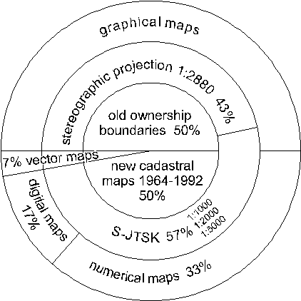
More detailed information is given in Figure 1, in which the outer circle represents the total territory of the Slovak Republic.
See for an explanation of the different types of cadastral maps the description of the cadastral maps in the Czech Republic (paragraph 2.1). Do not forget that the two countries were united till 1991 in one country, Czecho-Slovakia. Therefore the cadastral system (and its problems) are in principle the same in both countries.
ZM 10 consists of 2,820 map sheets and its content is, by means of separate printing forms, stratified into 5 topics. That means that 14,110 printing forms are to be scanned.
The Geodetic and Cartographic Institute creates and operates ZB GIS-Raster (ZB GIS-R). The creation of ZB GIS-R is carried out under the Methodical Guide for the creation of fundamental databases for geographic information systems in raster form.
The creation of ZB GIS-R is carried out by scanning the following separate printing forms - basic layers:
As a digital product from the Slovak Republic's territory ZB GIS-R will serve as:
The Basis Map 1:10,000 (ZM 10) was made by re-ambulation of the topographic map 1:10,000, which was published by the Central Administration of Geodesy and Cartography in the S-42 co-ordinate system. Aerial survey was used as a basic method of the re-ambulation. For the first time the ZM10 was published in the period 1969-1986, covering the whole territory of the Slovak Republic. Since 1981 systematic updating of a map series with differentiated publishing cycle has been started in dependence of the significance of the project territory (region). In updating the content within the framework of the ZM10 updating current aerial photographs are primarily used as a main source of information on the changes in the territory concerned.
Since 1992 the ZM10 has been issued in one version only, containing the cartographic network and the network of rectangular plane co-ordinates and points of horizontal and vertical control (up to 1991 marked as so-called 'secret version').
Unchanged edition is made only exceptionally. The condition of updating is given in graphic representation.
Digital map information also exists from the 1980s in Budapest and the quality of this data has been studied by a Swiss aid project. In the urban areas there are different demands for digital large-scale spatial data compared to those rural authorities located on the Great Plain. It is necessity to have accurate data concerning the exact status of the cadastral mapping on a national basis. A priority basis has to be established for deciding which maps are to be computerised first, as land registration purposes alone will not justify the investment.
The result of the compensation programme was the production of a digital database produced according to the Compensation Acts. This was transferred to the district land offices. From this information they can produce digital maps. A further activity is that the new compensation parcels have to be set out in the field according to the law.
The main problem for the cadastre is that in the Compensation Programme the owners did not got efficient land parcels, but more parcel slices, sometimes very small. The setting out of these parcels is a tremendous job. To improve the situation via land consolidation will take many decades.
The Digital Base Map Standard, Conceptual Model (Version 5.1) is a Hungarian standard proposal at this moment and was submitted to the Hungarian Standardisation Office. The aim of this standard is to describe the conceptual model of digital base maps. These maps should be the basis of different mapping activities in Hungary to form unified frames for land surveying purposes or for the establishment of spatial information systems.
At the level of conceptual model the standard defines the different types of objects, which create the content of digital base maps. Furthermore it describes the content and relationship features of geometric characteristics, data quality, and the method and principles of establishing the hierarchy of these objects. Also a comprehensive description on meta data is given.
The Digital Base Map (DAT - according to the Hungarian acronym) belongs to the so-called Unified National Map System (EOTR). It is compatible with the former 1:1000 - 1:4000 scale base maps in terms of Information Technology, content and data quality. In the DAT database objects are grouped in hierarchy of object class, object group and object type. Furthermore the Digital Base Map Standard regulates geometry, relationships, data quality, data protection, data consistency, etc.
F�MI has the intention to carry out the following projects in the near future:
With respect to the aerial photography it has to be taken into consideration that only those cities are photographed that made a request for it. Therefore there are no pictures taken from some important Polish cities. Furthermore, most of the cities have requested aerial photographs for some 20% outside the built-up areas.
With respect to the Land and Mortgage Registers we have now the following data available. The number of cadastral land parcels is about 29 million of which about 80% is privatised. There are 4.5 million buildings and about 10.8 million apartments of which 61% is individually owned. A very rough estimation is that about 35 million properties are individually owned. Because the number of registrations in the perpetual books is about 10,500,000 a rough estimation is that about 30% of the properties is registered. For a complete registration it is necessary to make a careful planning of the time and capacity required for this purpose.
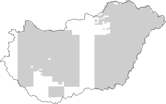
With respect to the quality of the information a research has been carried out in the pilot area of Pabianice in the voivodship �odz. Although it is difficult to extend the results of this research for the whole of Poland, it is certainly wise to suppose that there are many differences between the legal situation and the factual situation. This statement is illustrated by the map shown in Figure 4, where for a part of the City of Warsaw the legal boundaries of the plots are compared with the real situation. In the figure the dotted lines are the legal boundaries. These differences can cause problems in selling real estate, in mortgaging, in property tax, etc.
In rural areas, which includes about 65% of the number of municipalities in Poland, the digitising of the registers is almost finished. With respect to the cadastral map the estimation is that about 11% of the area is now available in digital form. Almost the whole of Poland (91%) is covered with cadastral maps. For a considerable part of the country, around 40%, the so-called supplementary maps were utilised as cadastre maps, or a simplified field survey was performed with the use of photo maps, which resulted in a lack of geodetic data to define boundary point co-ordinates. For this part it is almost impossible to transfer the maps into digital ones. In the 'Characterisation of the Existing Land and Buildings Registry System' in Poland the following fundamental deficiencies in the present Land and Buildings Registers can be distinguished:
Three types of maps on scale 1:10,000 are distinguished in Poland.
1st Category - urban areas;
2nd Category - not very densified built-up areas;
3rd Category - rural areas and forests, with not much topographic details.
Poland has a surface of about 312,000 km2. The area covered by one map is about 19 km2. A number of 18,000 map sheets is necessary to cover the whole territory of Poland with maps on scale 1:10,000. The maps on the boundaries of Poland, area each covering only a part of the Polish territory. The number is divided as follows:
1st Category - 1,950 map sheet:
2nd Category - 4,350 map sheet;
3rd Category - 11,700 map sheet.
Because the budget of the Surveyor General can only be partly spent on topographic mapping on scale 1:10,000 the strategy is as follows:
there are many changes on the maps, due to the privatisation, restitution and compensation programmes.
The best basis for a geographic information infrastructure are the 30,000 topographic map sheets 1:10,000. In most countries there are map series on scale 1:25,000 and 1:5,000 derived from the 1:10,000.
The base map must fulfil certain requirements with respect to:
Author's address:
Prof.dr. Theo Bogaerts
Subfaculty Geodesy
Delft University of Technology
Thijsseweg 11
2629 JA Delft
The Netherlands
Tel. +31-15-278 2553
Fax +31-15-278 2745
E-mail efendel@geo.tudelft.nl