Information Technology and Geographic Information System in the framework of Organization and business aspects in GIS
Dr. Angela Ionita
National Institute for Research and Development
in Informatics - ICI Bucharest, ROMANIA
e-mail: aionita@td1.ici.ro
Abstract
Geographic information technology is multidisciplinary in nature, combining computer, communication and visualization technologies to support application of geographical data in different disciplines. Development in computer science, applied informatics, digital data acquisition digital image processing and graphic science has led to the creation of GIS technology which integrates acquisition processing and presentation of geo-data. This new technology has created a new situation, which has removed the traditional border between various techniques within map production systems, as well as between map makers and map users. The technology has changed and will continue to change the understanding of what constitutes a map. The new technology has opened up quite new avenues of applications for data previously under-utilized due to inherent constraints related to the traditional form of information distribution using paper map technology.
This paper have eight sections and represent the point of view and the contribution of National Institute for Research and Development in Informatics - ICI Bucharest, Romania to PANEL-GI Package, chapter dedicated to organization and business aspects. In additional this paper benefits from a PowerPoint presentation (which counts 93 slides). Mainly points of interest of this contribution are: the point of view according to Information Technology, GIS and Organization,. The first section define the new technology GIS in connection with the evolution of Information Technology . The second section focused on the importance of Information Technology and the level of this in the communications era. The next section has as objective to discuss about the generic benefits of Information systems, the role of Information systems within and between organizations, Information Strategy and the difference between this and Information Technology. The fourth section has as subject the impact of GIS on people, from different points of view. The section dedicated to development of a GIS application had no intention to present a guideline because in generally the development of application in GIS depends on the technology's choice. the author has considered more important to present synthesis of different situation in order to offer to audience another point of view regarding the advantages and disadvantages of different options. this section includes also the principles of GIS application development and presents some misperceptions and pitfalls. By identifying some perceptions and misperceptions it is our hope that we can use GIS technology selectively and successfully to increase the quality and productivity of decision making, in general, and at the central and local public authorities level, in particular. We have addressed questions and misconceptions regarding GI-based systems because only by removing myths, laying open legends and recognizing facts can we develop the technical and managerial skills required to apply GIS successfully. The sixth section have been dedicated to enumerate and detail the lessons (to be) learned from GIS experience. Based on these ideas the next section it will be considerate like development guideline. The last section is dedicated to conclusions presenting the institutional changement, the possible partners/actors and the possible connections in this framework. Because the problem dedicated to economic aspects was the contribution of another partner in "PANEL-GI" Project, this subject is not presented in this paper.
The PowerPoint presentation have been enriched with few another ideas regarding the new paradigm of enterprise based on our own ideas [22] and based also on another presentations [5], [6].
1. Introduction
The new technology - GIS - has an integrating, decentralizing and customizing nature. The integrating feature, which has integrated the traditional production processes and information products, has removed the traditional border between various techniques involved in producing and using spatial data. The decentralizing character allows the integrated processes to take place in a decentralized fashion; (real exploitation of this character requires supporting infrastructure). The customizing characteristic let us produce a great diversity of information products at relatively low prices. This feature has created capability to develop new products that are demand driven rather than being technology or producer driven. This implies that economy of scale for geospatial products are no longer the only determinant; economy of scope becomes relevant.
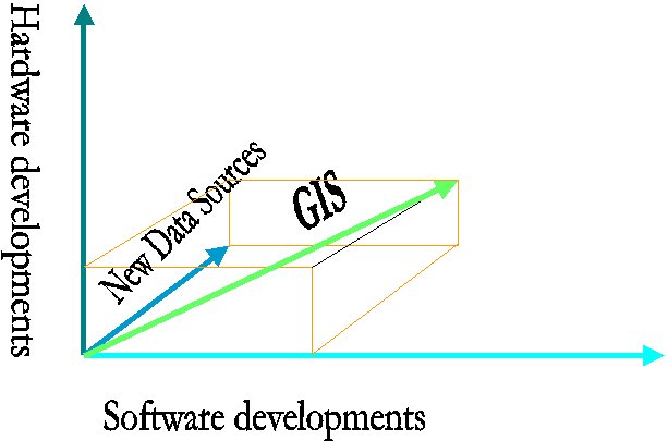
Now, geographic information system is distinguished from the geoprocessing of the past by the use of computer automation to integrate geographic data processing tools in a friendly and comprehensive environment. We may consider that GIS is an outcome of three aspects:
Hardware is the computer system on which a GIS operates. Today, GIS software runs on a wide range of hardware types, from centralized computer servers to desktop computers used in stand-alone or networked configurations. GIS software provides the functions and tools needed to store, analyze, and display geographic information. A review of the key. GIS software subsystems is provided above.
Figure 1: GIS
The most important component of a GIS is the data. Geographic data and related tabular data can be collected in-house, compiled to custom specifications and requirements, or occasionally purchased from a commercial data provider. A GIS can integrate spatial data with other existing data resources, often stored in a corporate DBMS. The integration of spatial data (often proprietary to the GIS software), and tabular data stored in a DBMS is a key functionality afforded by GIS. The generation of data from new sources is an on going development. Application developers have attempted to research and implement new data source into their work. Most of these new data sources are based strictly on scientific and technological developments.
Faster CPUs and high performance image processing and graphics processing finally provide a base capable of supporting distributed geoprocessing, which often involves intense computation and large data files. Wider bandwidth networks and distributed computing infrastructure (OLE/COM, CORBA, Java, etc.) and middleware and componentware architectures are important because so many geoprocessing applications benefit from transparent access to remote geodata stores and remote specialized geoprocessing functions, and from integration of geoprocessing functions into other workflow. "gIS" with a lower case g expresses the potential for open systems architectures and object technology to enable integration of geoprocessing as one (increasingly cost effective) subordinated component of applications and decision support systems. Growth in the use of geoprocessing will occur as middleware and componentware approaches release geoprocessing from the confines of large, expensive, complex monolithic software systems. Geoprocessing technology is proceeding as rapidly as the general computing telecommunications technologies, and not only in the area of geoprocessing interoperability interfaces. All of the following support the wider use of geodata and geoprocessing by every citizen: powerful spatial database technologies introduced by major database vendors; smaller and cheaper geographic positioning systems (GPS); sophisticated, inexpensive, and abundant commercial Earth imaging data products; advances in digital orthophotogrammetry for satellite Earth imaging and aerial still and video imaging; continuing specialization and product differentiation in the areas of GIS, CAD, and digital cartography; distributed interactive simulation; and three-dimensional spatial data visualization techniques (including interactive virtual reality approaches). These technologies hybridize in many ways. For example, high-resolution satellite images and digital orthophotogrammetry permit quite precise automatic generation of three-dimensional views of the Earth's surface. Perhaps the primary function of GIS is the data storage and retrieval. The ability to query and retrieve data based on some user defined criteria is a necessary feature and is based on the unique structure of the DBMS and command interfaces are commonly provided with the software. Most GIS software also provides a programming subroutine library or macro language so the user can write their own specific data retrieval routines if required.
Querying is the capability to retrieve data - a data subset - based on user defined formula. These data subsets are referred to as logical views. Many GIS software have standardized their querying capability by user with the flexibility to select their own DBMS. This has direct implications if the organization has an existing DBMS that is being used for satisfy other business requirements. There is a definite step in the GIS marketplace towards a generic interface with external relational DBMS's. Is becoming the norm of an external DBMS, linked via a SQL interface. The major development in GIS technology over the past years has been the ability to customize the GIS for specific and mainly is the ability to customize user interface and functionality through Application Programming Interfaces (API) and macro languages.
In our opinion, the alternative GIS architectures could be regarded, at least, according to the evolution of Information Technology and Communication (ITC), according to the development in DBMS field, according to the evolution in the area of distributed processing or according to the evolution of enterprise concept.
2. Organizations, People and GIS
Economic progress of a country depends directly on its ability to transform its resources into goods and services that satisfy the country's development goals. One of the prerequisites to the success of this process is the development and maintenance of effective national infrastructures for example for communication and transportation. Today, significant new infrastructure(s) is emerging, one is termed spatial data infrastructure. A major challenge to developed and developing nations is the viable development and integration of this information infrastructure into existing societal activities. Development in computer science, applied informatics, digital data acquisition digital image processing and graphic science has led to the creation of GIS technology which integrates acquisition processing and presentation of geo-data. This new technology has created a new situation that has removed the traditional border between various techniques within map production systems, as well as between map makers and map users. The technology has changed and will continue to change the understanding of what constitutes a map. The new technology has opened up quite new avenues of applications for data previously under-utilized due to inherent constraints related to the traditional form of information distribution using paper map technology [10].
According to [7], the new technology has an integrating, decentralizing and customizing nature. The integrating feature that has integrated the traditional production processes and information products, has removed the traditional border between various techniques involved in producing and using spatial data. The decentralizing character allows the integrated processes to take place in a decentralized fashion, (real exploitation of this character requires supporting infrastructure). The customizing characteristic let us produce a great diversity of information products at relatively low prices. This feature has created capability to develop new products that are demand driven rather than being technology or producer driven. This implies that economy of scale for geospatial products are no longer the only determinant; economy of scope becomes relevant. According to [18], this is expected, because information society builds less on economy of scale, and more on economy of scope, to match user information needs in their production process. All of these have important implications for map product development and GIS establishment, which in turn create great organizational impacts because unlike before, no single institution can be expect to be accepted as the sole leader in GIS development, and no one can claim monopoly over the technology [19].
GIS technology can play a decisive role in promoting economically and socially feasible solutions to the existing problems of various sectors of economy, where a variety of information needs to be collected from a variety of sources and must be integrated to plan, monitor, and evaluate development programs [11], [12]. To achieve goals such as "sustainable development", planners need to know what information exists, how good it is, how to obtain it, how much it costs, and how it can be merged with information from other sources. New technologies offer the opportunity to meet these and other needs. But unless the spatial databases exist and unless policies and standards are in place to facilitate the access to and use of spatial data on a broad scale, the opportunity is lost. What is required is a national strategy to direct the effort currently under way in the public and private sectors and to build a solid foundation for the communication, application and promotion of spatial data, through the gradual but systematic development of GIS infrastructure [16].
When it comes to Information Technology, horror stories abound in both the public and private sectors. Nevertheless, Information Technology has brought the convenience of revolutionary change to everyday life, from ATM machines at banks to global transfers of funds, from 800 telephone services to personal home computers, "e-mail", and the worldwide Internet computer telecommunications system. Whatever its problems, the information technology revolution is upon us. One author calls such technology the most powerful tool for change in the modern era [2].
American businesses, particularly the smarter ones, are taking notice. As the cover text of a recent book proclaims, "Computers and telecommunications are reshaping the basic structure of enterprise, and any competitive business must realize the new technology either to improve its products and services or to create entirely new ones [3]. The private sector is employing Information Technology to reengineer the way it does business, using human and material resources more efficiently and competing more effectively. Today, information technology can create the enterprise of the future. Finally, because the new technology allows a physical restructuring of the organization, making it less hierarchical, employees at all levels should be able to interact electronically, sharing ideas and helping one another with on-line resolution of information technology problems[17].
3. Information Technology in Organizations
Information Technology has two discrete functions in process reengineering [15]:
In our intention is to look at strategic planning for information systems in organizations. We consider:
3.1. The Generic Benefits of Information Systems
At a most general level, there are three ways in which an organization might expect an Information System to improve the performance of an organization. These are:
These three generic benefits are not watertight categories and often a single system will offer some elements of all three. In [21] suggests that in mainstream computing there can be seen a chronological progression from efficiency, through effectiveness, to competitive advantage
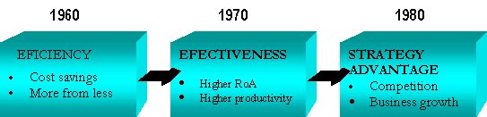
Figure 2: Chronology of Generic Benefits from IS/IT (Adapted from [21])
In fact we discuss about re-engineering of Business Process. Lets defining re-engineering
Practitioners have come up with a variety of definitions for reengineering. In essence, they boil down to this: business process reengineering is a systematic, disciplined approach for achieving dramatic, measurable performance improvements by fundamentally reexamining, rethinking, and redesigning the processes that an organization uses to carry out its mission [8].
Reengineering includes, as a first step, a critical reexamination of the organization's basic mission, goals, customers, and products and services.
As many practitioners point out [8], [15], [4], reengineering is not about refining the performance of current processes: it is about fundamentally changing them or creating new ones. A key premise of reengineering is that many processes that have become highly inefficient and ineffective. Only by rethinking the way work is done--often by taking advantage of information technology--can major, "order of magnitude" levels of performance.
3.2. The roles of Information Systems in organizations
Another way of considering the benefits, which can accrue from investing in Information Systems, is to identify the roles that they fulfill, and the levels at which they are used, within organizations. We will look at this from two viewpoints. First we look at the use of information systems within organizations, then at their use between organizations.
a) Within organizations
Here we meet the ”triangle” diagrams so much beloved by writers on organizational issues. Regardless of their particular spheres of activity most organizations develop broadly similar organizational structures. At a most general level, this ”typical” organizational structure is usually represented as a triangular structure.
At the base of the triangle is the ”Operational layer” where production processes take place. (Usually the organizational triangle is discussed in terms of manufacturing organizations, but clearly the triangle can easily be translated to consider service and public organizations, where ”products” are the services provided to customers and residents).
The middle layer consists of managers, researchers and administrators whose tasks include monitoring the performance of the operational layer, researching the external environment of the organization, and preparing policy options for the top layer.
The top layer of the organization, here labeled the executive layer, consists of the relatively small group of decision makers who determine the strategic direction of the organization.
The triangle model has found its way into textbooks in a very wide range of subjects including sociology, geography, economics and business and management. Its relevance here is that each layer has distinctive information requirements and hence demands distinctive kinds of Information Systems. It is thus possible to classify Information Systems according to the roles they play within the different levels of the triangular structure (figure 3, figure 4).
b) External roles
A limitation of the triangle model is that it focuses upon the growth of information systems within individual organizations. Information systems also have a role to play in improving efficiency, effectiveness, and competitive advantage between organizations (figure 5).
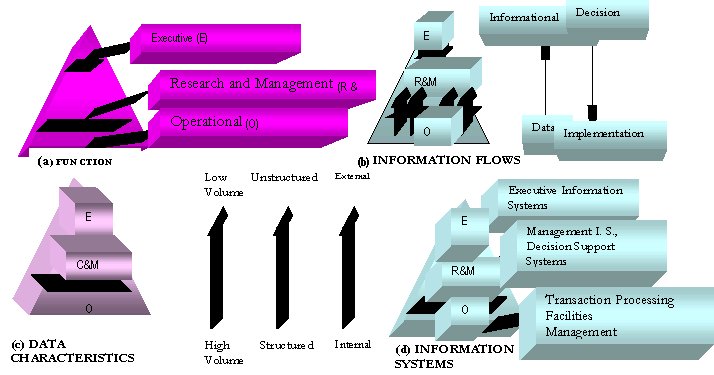
Figure 3: The triangular structure of organizations
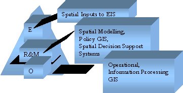
Figure 4: GIS within the organizational triangle
A lot of books are written about the Information System/Information Technology development process within organizations. Here, in the figure 6, we will only look at a skeleton of the most relevant ideas.
3.3. Information Strategy
”Strategy IS/IT planning is taken to mean planning for the effective long term management and optimal impact of information, Information Systems (IS) and information technology (IT), incorporating all forms of manual systems, computers and telecommunications. It also includes organizational aspects of the management of IS/IT throughout the business” [21]
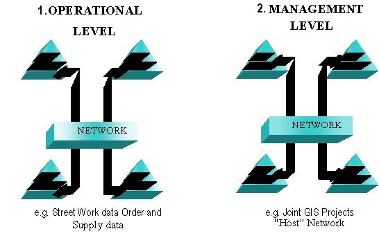
Figure 5: Inter-organizational Information Systems
Once an organization has in place a clear view of its mission in the form of an agreed Business Strategy, subsidiary strategy documents can be formed within each of the organization's functional areas to translate the Business Strategy into reality. Increasingly one of these sub-strategies will be a formal consideration of the organization's information processing requirements.
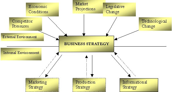
Figure 6: Business Strategy and Information Strategy
The distinction between Information Systems requirements (IS) and Information Technology requirements (IT) is often formalized by there being two separate and unequal documents prepared:
an organization's IS requirements.
Information Systems are introduced into organisations to change the way they behave. Information Systems can create and destroy jobs, cause changes in reporting structures, alter decision-making processes and cause shifts in the balance of power within organisations. Indeed some authors argue that Information Systems are fundamentally undermining the basic structure of organisations.
It must be expected that any GIS project will have some impact upon the shape of the organisation in which it is based. Groups that previously performed manual drafting tasks might contract, whereas opportunities for new computer-based staff will expand.
Looking at the cumulative impact of introducing Information Systems, it is reasonable to suggest that the relevance of the familiar triangular model may be being undermined. This model was, after all, developed prior to the widespread introduction of Information Systems at a time when organisations did require large numbers of clerks and middle ranking officers to sift and process data and even larger numbers of operational level staff.
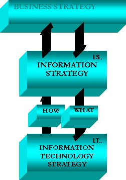
Figure 7: IS and strategies
The triangular model is based upon an essentially hierarchical view of organisations but introducing Information Systems tends to blur previously rigidly hierarchical reporting structures. With paper based systems memos and reports tend to be passed up and down the hierarchy of command and to be sent only to restricted distribution lists, but in companies which invested in Information Systems, information can be much widely available. Instead of waiting for middle managers to prepare paper reports, senior officer can, if they wish, tap straight into corporate databases. In companies, which have adopted electronic mail (and more recently groupware), executives can dip into the electronic mail-bag at any level, and conversely low level officers can easily bypass normal procedures and send messages to everyone on the system. To some degree, information flows are moving from ”hierarchy to ”ad-hocracy”
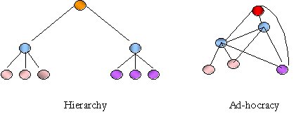
Figure 8: Hierarchy and Ad-hocracy
4. The Impact of GIS on People
[21] provides and discus an intriguing list of the characteristics of a good job:
Introducing Information Systems into the workplace can impact, for better or worse, upon every one of Alter's good job' criteria. Indeed, a feature of the effect of Information Technology upon jobs is that it is indeterminate in that so much depends upon the particular circumstances in which it is introduced. The same system could have widely differing impacts upon people depending upon the circumstances of its introduction – the attitudes of management, the job descriptions provided for operatives, the physical arrangements of the office, level of training and support provided etc.
If we look first at skill, Information Systems can often pose a threat to traditional skills. The term deskilling is used to describe the process by which introducing an Information System removes the need for traditional skills. With GIS, there is very obvious likelihood that GIS will dramatically reduce the demand for traditional manual drafting skills. Many people are intrigued by new technology and look forward to gaining new technological skills. Here the appropriate terms are not deskilling but reskilling.
5. Development of a GIS Application
There are three approaches (presented in [14]) typically used by organizations to develop GIS applications. Organisations can develop these applications in-house from scratch, interface with an existing shrink-wrapped GIS application or use a framework as the foundation for their customized GIS application. The strengths and weaknesses of each approach will be considered here.
|
Advantages |
Disadvantages |
Maintain control of project using in-house staff. |
In-house staff may not have sufficient expertise in building GIS's. |
Maintain control of functionality. |
Longer development time. |
Application is customized to the needs of your business. |
Limited functionality due to limited resources. |
The primary advantage in building a GIS application in-house can be summed up in one word - control. Because you are using your own staff, you have more control over what functionality is delivered, and when it is delivered. However, this control comes at a price. Building a GIS has its own unique set of challenges not found in other types of applications. You need user-interface experts, graphics experts, database experts, and performance tuning experts. Does your staff have the expertise? Do you have time or budget to train them? The lack of availability of these experts can significantly stretch the delivery time of your project, even prevent your project from ever delivering.
|
Advantages |
Disadvantages |
More complete set of GIS functionality than could be developed in-house. |
Limited functionality - Your application must do the things defined by the vendor's application. Nothing more. |
Not limited by in-house resources and expertise. |
Limited configurability - Can you change the way things work? Even if the vendor's application supplies the desired functionality, it may not be implemented in the most efficient manner for your particular application. |
Quickest development time. |
Limited flexibility - If your application's requirements change, can the vendor's package change along with them? |
|
|
The application vendor doesn't know your business, so there's a high likelihood that their application won't meet all the needs of your business. |
|
|
Extending a shrink-wrapped application can be very expensive and time-consuming. |
Using a shrink-wrapped GIS application as the nucleus of your own application allows you to deliver a completed system much more quickly than by developing it from scratch using in-house developers. The application vendor is most likely experienced in developing GIS systems, so they assume this risk for you. And it's likely that the shrink-wrapped application will contain a much more comprehensive set of GIS functionality than would ever get trying to develop it in-house. And most likely you will be able to deliver your application more quickly than by building it all yourself. But there are still important problems with this approach. While the GIS system vendor may know GIS, they do not know your business, and so may not implement the GIS functions in the most efficient manner for your needs. And if you want to do anything the vendor has not anticipated, you may be out of luck. Another problem is limited configurability. Even when the vendor product has the functions you need, you are forced into doing things their way, even if you would have chosen something different. And if your requirements change, or you need to add new functionality at a later date, the vendor package may suddenly not meet your needs.
|
Advantages |
Disadvantages |
|
More complete set of GIS functionality than could be developed in-house. |
. |
|
In-house resources can be used for parts of the application where their knowledge and expertise is greatest - your business. |
. |
|
Quicker development time - Much faster than in-house development from scratch. |
Product delivery not as fast as with shrink-wrapped application. |
|
Unlimited functionality - What is not supplied by the framework vendor can be easily added. |
|
|
Unlimited configurability. - Functionality supplied by the framework may be modified and extended to meet your specific needs. |
|
|
Unlimited flexibility - The framework can be changed as needed to meet changing requirements. |
|
What is needed is a solution, which leverages someone else's GIS expertise while allowing you to customize the application to your specific business needs. That solution is to use a framework. A framework has most of the hard work already done for you. It provides the foundation for your application, which contains all the GIS, functionality. It allows you to build the business-specific parts of the application on top of that foundation. And it allows you to customize the GIS behavior to meet the specific needs of your application. It takes full advantage of the power of object-oriented programming to maximize reuse and minimize the effect of changes. You get the benefit of using someone else's GIS and graphics experts while using your own business experts. It is truly the best of both worlds.
5.1. Principles of development of a GIS Application
The development of a GIS Application has been designed around the following principles: modularity, extensibility, configurability, non-intrusiveness, and scalability.
Each of these principles has been examined in detail in [14].
GIS Application will be modular.
A GIS Application consists of a number components, each of which carries out a specific set of responsibilities in the framework. While each of the components interacts with other components/subsystems to fulfill its responsibilities, these components are loosely coupled. This loose coupling is accomplished using a role-based application architecture. Components in the framework fulfill specific roles, which defines the interactions with other parts of the framework. The primary advantage of this approach is that many different versions of an application can be developed. Different applications may be delivered using different user interfaces or database support, all on the same framework. This is accomplished through use of a system configuration, which defines what roles are present in the system and what specific classes fulfill each of those roles.
GIS Application will be extensible.
In many cases, new functionality can be added easily by subclassing existing components. In the cases where subclassing may not be enough, new components can be easily created and added to the system configuration.
GIS Application will be configurable.
Not only can new components be added easily, but also existing components can be configured to work in different ways specific to a particular application. It allows different applications to use different indexing techniques for retrieving GIS data.
GIS Application will be non-intrusive.
Other frameworks and add-on products are extremely intrusive to the user's domain. That is, they require domain objects to support special protocols and sometimes even require the addition of instance variables. This can make it extremely difficult to integrate existing domain objects into the framework, and can sometimes prevent the addition of other add-on products because they require changes to your domain which are mutually exclusive. GIS-specific behavior is abstracted away from the user's domain. It should be noted, however, that non-intrusiveness comes at the price of having more objects in the system.
GIS Application will be scalable.
Because a GIS deals with large amounts of data (millions of objects), it is important to use indexing techniques to optimize access to these objects for certain queries. One of the most commonly used techniques is called spatial indexing. Spatial Indexing organizes data in order to optimize multi-dimensional range and point queries.
A difficulty comes from the fact that the applicability of indexing techniques is very dependent on the topology of the data in question, i.e. the choice of caching techniques is dependent on the application it is being used in. Traditional approaches choose one (or maybe two) type of indexing and use them for all the applications that are built. A given technique may be very effective for databases with 30,000 objects that are evenly distributed, but may begin to fail as the data becomes clustered or the number of objects approaches 500,000. The point is, no one technique or set of techniques works for all situations.
The development of a GIS Application framework is designed to not only allow different applications to use different indexing techniques, but also allow the same application to employ multiple techniques simultaneously. This implies two different abilities:
Through time, as users become more experienced with GIS, they require more complex applications. The "initial document" (feasibility study, specification of requests, terms of reference etc.) will contain some applications of a complex nature, however the majority of initial applications will be straight-forward, using the basic functionality that is part of every commercial GIS (e.g., query, display). The more complex applications usually are not supported by the basic functions of a GIS but must be programmed using the GIS macro language or other programming language. The "new document" identifies several categories of applications that must be prepared by users and how overall requirements change over time (see figure 8).
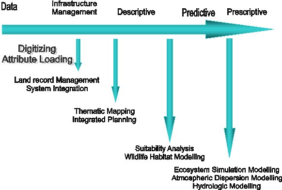
Figure 9: GIS Application Domains
Source: Buckley, David, "The GIS Primer - An Introduction to Geographic Information Systems",
Innovative GIS Solutions, Inc., Feb. 1997 [1]
5.2. Misperceptions and Pitfalls
By identifying some perceptions and misperceptions it is our hope that we can use GIS technology selectively and successfully to increase the quality and productivity of decision making, in general, and at the central and local public authorities level, in particular. We have addressed questions and misconceptions regarding GI-based systems. They are not simply research curiosity. Nor are they panaceas for many problems we face today. Instead they are viable technologies that provide a fresh approach to solving many decision problems. Only by removing myths, laying open legends and recognizing facts can we develop the technical and managerial skills required to apply GIS successfully [12].
To manage and use GI it is imperative that we understand its capabilities and limitations. This approach in identifying problems and misconceptions will be to examine questions and assertions that have been posed to us over the years.
Applications based on GIS replace conventional approaches
Some applications based upon conventional technical solution such as management of files combined with CAD products and some programs for reasoning generate optimal solutions for some problem classes at the local level (for example: the commune level). If this combination exists, use it.
On the other hand, the local level differs from specific problems. In this case, the same solution provides a ”satisfying” approach, at the most; it does not guarantee the optimal solution for all aspects. Consequently, GIS technologies are useful whenever a conventional approach does not exist.
Applications based on GIS are easy to build
The ease of building an applications depends on the amount of work required to map the problem into software, which can vary from easy to difficult.
Small prototypes can be scaled up into full-scale solutions
Using today’s powerful tools it can construct prototypes quickly with ”pretty” interfaces. This not only gives managers a false sense that the problem has been solved, it also misleads decision-makers and experts.
The heart of the problem is whether the problem - solving method used in the prototype - which solves only a small portion of the problem - will scale up to solve the entire problem.
GIS are easy to maintain
If the desired data is not available on the market, or it is available but not on the required quality level, the institution has to build up the GIS in-house or to contract it out to a digitizing company. First step will be to think about the data-model. The model is very important with respect to the usability of the data. It should be defined clearly, easy to understand and not too extensive. The more clear and understandable the datamodel is, the smaller the risk of systematic errors due to misinterpretations. Sampling of geo-data can be seen as a production system. This process uses common resources, which are referred as the "five M's": men, machines, methods, material, and money.
Managing GIS differs from conventional project management
Due in part to academic ignorance of requirements for building production - level systems, an incorrect belief prevails that managing GIS should differ from managing conventional system engineering. Rapid prototyping is an important means for acquiring problem requirements and specifications and for eliciting and verifying knowledge maps. The success of rapid prototyping indicates that the waterfall model of software development is inappropriate for many GIS projects. Instead, the spiral model is the most suitable means for managing the construction of conventional and GI - based systems alike.
All GIS components are the same
There are many GIS software packages available in the market place. GIS differ considerably
in the methods they adopt to store data and particularly in the nature of the links which they
maintain between attribute and geographical data.
Learning a GIS is all we need to know about GIS
GIS is composed of many fields, each contains many theories and techniques. Because GIS practitioners tend to be computer scientist they have been good at constructing programming languages and environments that incorporate compacting theories and techniques. In some cases, programming tools are direct embodiments of theory. In most cases learning a GIS does not teach as much about GIS theory.
5.3. Common Pitfalls
Several pitfalls exist that most often contribute to the failure of a GIS implementation strategy. These have been mentioned in [14] and enumerated below:
1. Failure to identify and involve all users
Users in an operational GIS environment consist of operations, management, and policy levels of the organization. All three levels should be considered when identifying the needs of your users.
2. Failure to match GIS capability and needs.
A wide spectrum of GIS hardware and software choices currently exists. The buyer is presented with a significant challenge making the right choice. Remember, the right choice will be the GIS that provides the needed performance no more, no less for the minimum investment. The success of a GIS implementation is particularly sensitive to the right hardware and software choices !
3. Failure to identify total costs.
The GIS acquisition cost is relatively easy to identify. However, it will represent a very small fraction of the total cost of implementing a GIS. Ongoing costs are substantial and include hardware and software maintenance, staffing, system administration, initial data loading, data updating, custom programming, and consulting fees.
4. Failure to conduct a pilot study
The GIS implementation plan concerns itself with the many technical and administrative issues and their related cost impacts. Three of the most crucial issues, are database design, data loading and maintenance, and day-to-day operations. The pilot study will allow you to gather detailed observations, provided it is properly designed, to allow you to effectively estimate the operational requirements.
5. Failure to consider technology transfer.
Training and support for on-going learning, for in-house staff as well as new personnel, is essential for a successful implementation. Staff at the three levels should be educated with respect to the role of the GIS in the organization. Education and knowledge of the GIS can only be obtained through on-going learning exercises. Nothing can replace the investment of hands on time with a GIS !
6. Lessons (to be) learned [10], [13], [14],
Strategic use of GI has a fundamental requirement that GI be linked to the business strategy. By definition such applications have to support one or more of the key goals (or critical success factors) of the business. In some of the organizations this link to the business had been articulated via the information strategy, in others it had not. This is an interesting observation, which warrants some further discussion.
For example, in most CEEC there was no explicit mention of GI in the information strategy. The reason given for this was interesting, namely that GIS as a technology was relatively freestanding and did not have a major (or strategic) impact on other information technologies used elsewhere in the business. This is a view of information strategies, which is essentially one dominated by the importance of information technology strategy. Information strategy comprises issues of technology (IT), systems (IS), and management (IM). Taking this wider view would encourage organizations to consider GIS in terms of what strategic importance for the business could be unlocked from the geographical data contained in internal files (an IS issue).
The benefits of using GI for supporting strategic decisions are notoriously difficult to quantify. A strategic benefit is by definition one that contributes towards the achievement of the business strategy. Benefits are most likely to be measured in terms of the effectiveness of GIS to achieve "different things", often referred to as the transformation of the business. The ultimate level of transformation identified by Scott-Morton has been difficult to identify in practice; it remains to date something of a theoretical state. In more practical terms it is likely that the benefits can be measured more in terms of value added.
The cost availability and transferability of data is dependent on the circumstances of the country or group of countries that the business is analyzing. Confirmation of this view is at hand when it is realized that most of the examples reviewed come from the USA. It is in the USA that data is most widely available at a price that is economic to apply to the applications considered here. Standards have been agreed and adopted, and there is a well-developed market of data agencies that sell value added geographical information products.
All case organizations reviewed had a very mature information technology infrastructure. The business is well supported with information systems for a range of business processes. Staff has a balance of technical (computing) and business skills. There is a co-operative structure of management which helps build consensus amongst user groups and helps to support applications which users both need and want. Organisations with these kinds of characteristics are the ones who will most likely adopt GIS for strategic business support.
GIS is likely to become just another part of the whole information system of the organization. The fact that it handles spatial and attribute data will be largely unnoticed by the user community.
Like many of the descriptive adjectives that precede the words "information system"; executive is something of a misnomer. The taxonomy of information systems provides a more realistic way of describing and assessing information systems. The three "T's" of task, timeframe, and technology combine to provide dimensions on which information systems can be discussed. Executive information systems become a redundant term.
The relevance for GIS can be discussed in terms of task. Executives or top managers will generally be concerned with unstructured decision making for strategic planning. GIS can fulfill some of these tasks. The issue posed is something of a red herring. A more meaningful question might be to ask how maps could be used effectively by executives. The likely scenario is for mapping to become more widely accepted as a form of output from a range of information systems. In a sense this will be a measure of the extent to which GIS is being integrated into the business.
7. Development guidelines [13]
1 - Development of the necessary organizational structure. Including structure at the highest levels of government as well as structures within user community. Dominant factor to the success in development and implementation of GIS, is the mandate and dynamic leadership by the national organization assigned to this responsibility. This shall include organizational structures at various levels dealing with human resource development, promotion and adaptation of the new technology, systems support and mechanisms for sharing and exchanging data dissemination application, and providing the necessary financial resources. The purpose and mandate of such organization shall be, promotion of the efficient use and sharing of geographic information, co-ordinated development of geographic information systems and policy governing these, to avoid wasteful duplication of effort, and assure yielding high quality data for the potential and existing development and application programs. The challenge for this organization will be to define the infrastructure (foundation) upon which the user community can integrate data that are collected and maintained by various sectors for specific purposes.
2 - Establishment or enhancement of the capabilities of the producers, users, and their supporting disciplines of the spatial data to conduct their missions. Including the development of skills, applications, and systems in support of geographic information. This shall include:
3 - Development of facilities to promote sharing, flow and communication of information. This can be achieved through the following activities:
4 - Identification and development of priority spatial data bases based on the requirement of the user community. This shall include:
5 - Development of policies to address financing, costing, and pricing strategies as well as the ownership, rights and liability issues.
6 - Training and education: The most fundamental conditions of transfer of any new technology are the awareness of its existence among professionals, although adoption of new techniques does not automatically follow from awareness of them. For a substantial body of managers in administration and commercial sectors the notion of "GIS" is not known. The possible applications of GIS are also not recognized and not considered as important or useful by the majority of potential users, such as geographers, planners. Therefore, a variety of educating and training programs with various orientation and specialization at various level are required. These can be classified as:
7 - Research and development: The successful transfer of technology largely depends on the availability of indigenous technological and innovative capabilities. Historical perspective shows that a technology is well transferred, absorbed and becomes an integrated part of an economic system, if the receiving society can take responsibility for developing some elements of that technology [20]. The area in which such contribution should occur, is not necessarily building the sophisticated hardware and software, but adoption and development of technology based on local needs. This is only possible through research and development programs.
8. Conclusions
New technologies are transforming the industrial economy into a marketplace driven by information and knowledge. In the knowledge age (Toffler 1990), the customer (or constituent) is empowered to demand increasingly sophisticated solutions (e.g., high quality and low cost) and organizations are required to focus on core strengths and efficient execution. This combination of empowered customers and focused providers creates a fertile environment for partnerships. Partnerships of all kinds (e.g., employee teams, strategic alliances, interdisciplinary research centers, international trade agreements, virtual organizations, and government-business co-operative agreements) are being formed to bring together unique combinations of financial, intellectual, technical, and political capital. The knowledge age will require (and be fostered by) a proliferation of these and many other new and innovative partnerships.
Institutional Change
Clearly, government, business, and universities are changing. Business conglomerates have been abandoned in favor of outsourcing and virtual organizations; and comprehensive research universities are reorganizing around areas of academic strength. Each institution is being asked to achieve more with limited resources in a rapidly changing environment. A vital part of this transformation is the ability to initiate and execute partnerships.
Leaders must acknowledge the awesome potential of partnerships and promote the difficult work of changing cultures, reducing barriers, and overcoming stereotypes. For example, businesses must view universities as an extension of their research and development efforts, government must view universities and business as partners (not contractors) in developing national solutions, and universities must view business and government as sources of challenging intellectual problems. As new partnerships emerge, they must be nurtured, studied and improved.
If we consider three institutions - government, business, and universities - and assume that partnerships have only two participants there are six generic partnership combinations. For each of the six combinations, innovative partnerships will emerge that dramatically affect society and the spatial data community. Here are some possibilities:
(1) Government - Government (GG)
Global markets will increase the need for international co-operation at the same time that many new countries are being created. Nations will routinely create political, economic, military, regulatory, and technology alliances. With respect to spatial data, it is likely that a federation of countries will field a high resolution imagery system in direct competition with the private sector.
(2) Business - Business (BB)
Spatial data costs will decline dramatically perhaps to the point that spatial data becomes disposable (i.e., the marginal cost of reproduction exceeds the cost of primary data acquisition). Many spatial data providers will emerge due to inexpensive and reliable data acquisition and distribution technologies. At the same time many new uses of spatial data will be identified. In the presence of many spatial data providers and many spatial data users it is likely that a commodity exchange will be created where standard spatial data products are traded. Spatial data will be viewed as a fungible good if it meets established data format and accuracy standards. Because spatial data will be extremely inexpensive to gather, the unique spatial characteristics may even become irrelevant. Consider, for example, that every parcel of real estate is unique, but the related mortgages are routinely packaged and traded in financial markets.(5) University - Business (UB)
A university consortium will be formed to deliver spatial data technologies to industry. The entity, perhaps called a Master Licensee, will be awarded exclusive technology licenses for all spatial data technologies developed by member universities. The entity would likely be operated as a not-for-profit but with significant performance incentives for management. The Master Licensee would essentially partner with businesses to commercialize emerging spatial data technologies. It will also be possible for the Master Licensee to fund spin-off companies, perform incremental technology development, and provide a technical support infrastructure for its business partners.There are biases, even in well-managed organizations that inhibit the creation of innovative partnerships. New business processes must be devised to identify and create new relationships and acknowledge them as a source of competitive advantage. Of the six generic institutional partnerships (i.e., BB, GG, UU, GB , UB, and GU) discussed above.
The most activity and innovation is present in Business to Business (BB) and to some extent Government to Government (GG) partnerships. For example, BB relationships such as Value Added Reseller (VAR) and Value Added Partner (VAP) programs provide a glimpse of the future of innovative partnering. While there is a long heritage of Government to University (GU) partnering, it has been a sponsored research (i.e., contractor) relationship that is not in the spirit of a knowledge age partnership.
In the future, GU relationships will encompass a combination of production, development, and research activities, which will require both universities and government to become more flexible. Cultural and political barriers inhibit inter-institutional partnerships like University to Business (UB) and Government to Business (GB) relationships. Reducing these barriers will take time; however, there is great potential in these relationships (e.g., Germany's Fraunhofer model).
University partnerships (UU) will make the slowest progress partly because many academic institutions view themselves as holistic, stand-alone programs. Distance learning technologies combined with the need for life-long education will ultimately drive UU co-operation.
References
Innovative GIS Solutions, Inc., Feb. 1997