H. Nechniche*, K. Brahimi**
* Laboratoire de Géomatique - CNTS Centre National des Techniques Spatiales -
B.P. 13, Arzew 31200 - Algérie - Tel:213 41 47 25 82 - fax: 213 41 47 34 54
** Institut de Génie Civil d'ORAN -USTO -Algérie
The technology improvements together with evolutions due to the decentralisation of services and data processing developments have deeply modified most professional practising in many fields. This variety of fields have a spatial reference and are generally dealt with through Geographical Information Systems (GIS).
Recent awareness for information economic, strategic and social dimensions and the major role of related techniques have lead to an important increase, world-wide of software packages for management and processing usage of spatial referenced data. Even if the use of such tools covers a many fields, thus concerns many products as users needs, it necessitates however several primary treatments such as collecting, cleaning, structuring and updating data and if necessary discarding whatever are useless, etc..
What is particular in studies related to spatially referenced database is embodied in the fact that they require the implementation of several processes that may solve problems rising from the control of a huge data volume. Such data control is very complex to deal with since it uses two kinds of data : descriptive data (attributes) and spatial data (geometry and topology).
These processes are carried out in successive stages and the quality of the data base is largely dependent.
A current project was carried out to implement a national road database at the "Centre National des Techniques Spatiales (CNTS Algeria)". This project entitled R_ROAD (standing for Réseau Routier Algérien Digitalisé) is aimed at implementing a digital representation of the northern road network in Algeria. In addition, the project aimed at implementing the general investigation tools that will allow potential users to undertake various specific applications.
This paper is aimed to defining the particularity of the road data structuring and modelling. It is also intended to describe the structure of geometrical algorithms that are used for cleaning and correcting the recorded files.
Besides, the description of the particular case of our database, the built up model and steps that allow the development of the Data Conceptual Model will be presented herein.
Key Words:Modelling - GIS - Data structures - Networks - Spatial databases.
The technology improvements, especially computing sciences, together with evolutions induced by the decentralisation of different services and data processing developments have deeply modified most professional practising in many fields. This variety of fields may be public or private have a spatial reference and are generally dealt with through Geographical Information Systems (GIS).
Recent awareness for information economic, strategic and social dimensions of the information society and the major role of related techniques have led to an important increase, world-wide of software packages for management and processing usage of spatial referenced data. Even if the use of such tools covers many fields, thus concerns many products as users needs, it requires however several primary treatments such as collecting, cleaning, structuring and updating data, etc..
Among all supports that are of interest in any territorial planning scheme, transport infrastructures are the most important because of their strategic character in the current development and no one can deny this whenever. The predominance of road network in any territorial cartographic representation is a good illustration, as the network constitutes the main framework.
Current and future needs for applications related to road geographic information are too many. In fact, road traffic management and optimisation, road maintenance and accident control operations are very difficult to meet by usual and traditional means such as plans, maps or photographs.
Software share, in solving problems related to road traffic management and control or optimal path searching increases because of their commercial and strategic aspects. This induces the need for the development of production and digital data manipulation thought the implementation of thematic databases that may help solve the expressed needs. However, a spatial referenced database is not an end in itself; it requires the development and implementation of software or geographic information systems well adapted as needed.
Geographical information is defined in a general context as a link between an object or a phenomenon and its position on the earth surface. It is therefore a combination of graphic information and alphanumeric information, which can be shown very clearly by drawing means. [1]
Geographical information concept stands for a variety of data, such as natural resources distribution (soils, waters, vegetation, etc..), infrastructures localisation (roads, different facilities network, buildings, etc..), administrative boarders. Even population statistics data can be enclosed in such a definition since they have a spatial extension. [2]
A road geographical information is an information related to any entity in direct or indirect relation with the road network. It comprises the road network description properly as well as the elements in relation with this network. It is essentially of a linear kind and this imposes the use of processing systems that are able to deal with vectorial data kind during the structuring process (vector GIS). [1]
This information is constituted of two components: a "geographical" component that describes the network geometry as well as the topological structure (location, entity dimensions and its neighbourhood study) and a "descriptive" or "semantic" component that lists the attributes associated to the entity under study.
Thus, a road section will be described geometrically by a set of coordinates with start and end nodes (geometry and topology) and a series of features such as road width, pavement kind, ground level, etc.. for the semantic component.
The road data base (R.D.B.) is a database of road geographical information. The main objective sought for when conceiving it is to provide the necessary information for organising movements on the road infrastructures. But, such a database allows also for other applications to be completed, as the road traffic management, road cartography, traffic optimisation, etc.. [3]
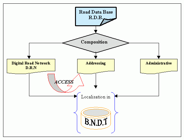
Figure 1 represents the constitution sketch of our data base, this database is composed of three specific entities: " Digital Road Network " Entity, " Addressing " entity " and "Administrative " entity .
Figure 1. R.D.B constitution sketch.
One distinguishes the notion of Digital Road Network (D.R.N.) which is a digital representation of the road network and the notion of R.D.B. which is a made up of the above D.R.N and other entities spatially referenced. This entities may come from other databases and are indispensable for describing the network and its environment (such as administrative limits, road equipment, built up areas, etc..).[5]
To develop a road database it is necessary to carry out several operations and particular works, according to an organised and thoughtful process. In fact, the use of raw data is inappropriate nay even impossible. generally one carries out the following operations in sequence : data preparation, their acquiring, their conversion and their integration. [2], [4]
The complexity and specificity of geographical database setup in general, and road one particularly require the implementation of several processes passing through different steps, among which the following are cited:
One of the fundamental stages in the constitution process of a geographical database is the data modelling (development of the conceptual diagram and the data dictionary).
This modelling aims to producing a representation of reality, in terms of the aimed goal and should be irrespective of the used technology kind. It is based on notions of entities, relations, cardinalities and identifiants that must verify principles of significance, no redundancy, consistence and normalisation. [6]
A geographical information system (GIS) is a computer system, whereby physical or socio-economic data are dealt with. These data can be related to a located entity.
This system is characterised by a set of more or less developed functionality.
The GIS serves as supports to applications that handle geographical data such as urban planning, dealing with natural resources, cadastral survey, traffic management, etc.. They are information systems whose objective is an information for relationship between an object (or a phenomenon) and it referenced location on the earth surface. [9]
Strictly speaking, the term GIS means a software package, but it can be extended to include the equipment: computer and peripherals, data (database), applications or self user treatments and organisational infrastructure (personnel, supports, facilities, etc..).
The implementation of a geographical information system leads to make choices about the content, the way of constitution and management of the database.
Choice of the content: the choice of road data to be integrated into the database is established in collaboration with the user who makes up a list of headings and defines a methodology for information processing. These headings can describe the main geometric features of the studied road, the pavement structure features, road usage characteristics, road environment, its functions, technical or administrative ranking, etc..
While creating a database, it is necessary to take into account the fact that data may come from different sources. The geometric data may be taken from maps, aerial photographs, satellite images or field survey, while descriptive data are either collected at actual sites, or provided by the technical services staff. This diversity of sources and supports, brings about problems of data homogeneity, that must be considered imperatively in the database.
As for the data base management, one should make room for a number of operations such as :
The structuring is a way of to organising data and the links that exist between them. The word data structuring is sometimes used to designate the physical organisation of data and the links between data in a software.
Geometrical structuring operations consisted broadly in many actions:
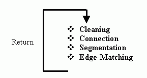
Generally, these operations are generally interdependent, and affect directly the quality of data put in hands of potential users. For this, a particular attention has been paid to carry out the works leading to their definition.
Files cleaning
The operations of digitisation are followed by file cleaning operations. This stage assures connections and discards errors of wrong digitalisation which are unavoidable errors.
The inaccuracies of digitisation are of different kinds and happen in different ways. Those which appear frequently in vectorial data are reviewed hereafter.
The algorithms set up are related to files cleaning in order to eliminate several kinds of errors among which the following are examples :
Awkwardness errors bringing on the appearance of summits in a geometric line. Figure 2-a
Nodes connection lacking errors. Figure 2-b
Error of drawing passing near limits giving non significant sections. In any case, road sections whose lengths are less than the graphic error are non significant, because of the data input scale. Figure 2-c
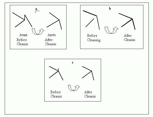
Figure 2. Digitalisation errors
Summits connection
This operation allows the connection of objects when the distance between them is smaller than the graphic error, the following examples concern the two the most frequent cases of the linear objects:
Linear objects connecting at the summits:
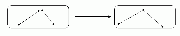
Figure 3 . Nodes connection
To detect and correct errors related to linear objects which should be connected at the summits, the steps were as follows:
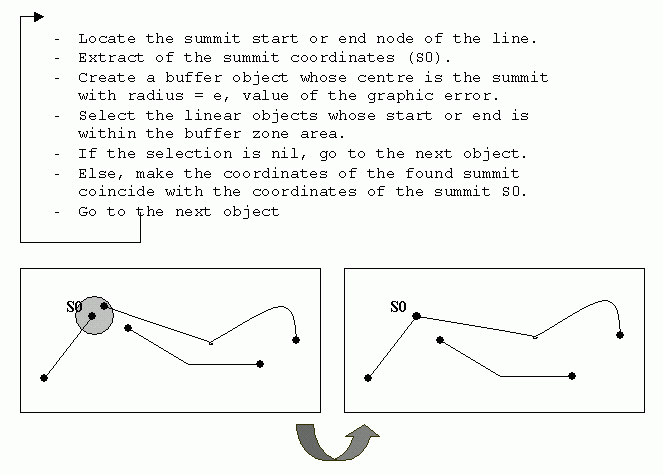
Figure 3b . Summits connection procedure
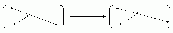
Figure 4 . Creation of nodes
The geometric structuration that allows the connection of a summit line to a line object has been done as follows:
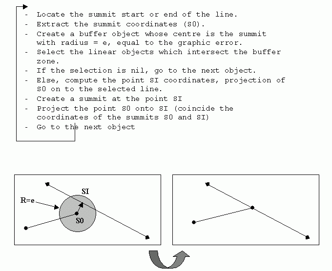
Figure 5 .- Summit creation procedure
Objects creation (Segmentation)
This operation consists of the automatic creation of linear objects from existing objects.
The model set up allows this creation of objects to be made in two ways:
The change of at least one descriptive attribute or
The intersection of geometric objects
If the first case is easier to deal with; the later is more difficult and brings on three possibilities of treatments:
i) An object looped around (figure 6):
This is a frequent case, where during the digitalisation, loops are formed. And even if the intersection is made at different high levels, drawing rules require to represent the intersection by a node. Thus, unique linear object is split into three linked objects.
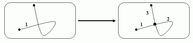
Figure 6 . Linear object looped around
ii) An object meeting the end of another object (figure 7):
This following procedure is generally a logical result of the summit creation procedure; indeed, it is a particular case of the following one.
Two objects intersect in such way that the summit of the first line intersects the second line.
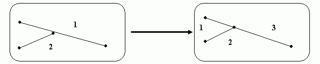
Figure 7 . An object summit intersecting a second object
iii) Two objects intersecting each others (figure 8):
When two linear objects intersect, the procedure creates four connected segments.
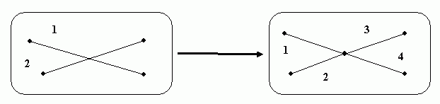
Figure 8. Two linear objects intersecting
Edge - Matching :
This type of inaccuracy results from the grouping of two or more maps, such is the case of the what is called Edge-matching.
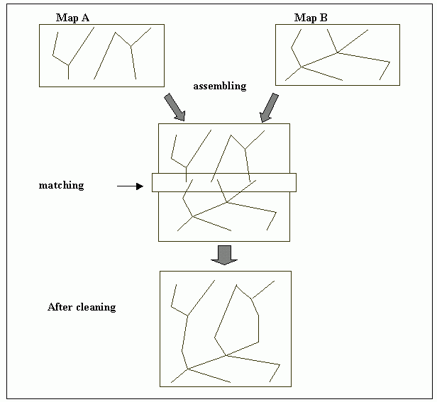
Figure 9. Edge Matching principle
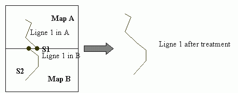
Figure 10. Edge-Matching procedure
The edge-matching algorithm consists in:
All these irregularities owing to human being are unavoidable. Then operator should be knowledgeable and qualified (experienced, patient and skilled)
To satisfy the kind of needs mentioned above, a project (included in the national research program) for the implementation of a national road database has been completed at the "Centre National des Techniques Spatiales" (Arzew-Algeria). This project entitled R_ROAD (standing for Réseau ROutier Algérien Digitalisé) aims to set up a numeric representation of the northern Algeria road network. It also aims to implement general investigation tools that allow potential users to complete various specific applications. It will be included into a set of road data and will complete other data derived from other sources and constituting a Road database. This database result from a particular structuring of located data linked to a unique database, which may be the National Topographic Database (N.T.D.B.) 9],[5]
In the R_ROAD project scheme, the road data modelling is the main work executed in order to implement them in the database. The aim objectives sought for are mainly:
To meet these objectives, the project goes through several steps, among which:
A general and exhaustive model of the database has been conceived (Figure 11), from which a simplified sub model was drawn and comprises the road network entities (Figure 12 ).
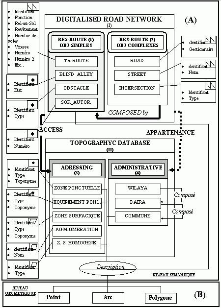
Figure 11 . General model of the database
This product is appropriate to solve many applications. These applications may concern the management of road network elements or of the management of entities that have direct or indirect links with network components.
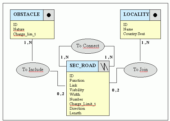
Figure 12 . Data conceptual sketch
Besides, such a product cannot be satisfactory neither functional through time, unless the data are always updated. Because of this, we paid much attention to the data updating process. Thus the data updating process have been dealt with correctly.
A prototype was developed for the validation of the methodological approach. This provided a scientific base for its generalisation to the national network as whole. The product is based on a set of "software - data " implemented on a P.C. platform accessible to the great number of users.
ID | Sequential Number |
Function: | Highway Speedway or access way others |
Liaison: | Principal Secondary |
Viability: | Paved Ameliorate partially ameliorated |
width: | Separated roadways 2 large ways and more 2 ways 1 way |
Number: | Character |
Charge_lim_t: | Numeric |
Direction: | Direct Inverse |
Lenght_Km: | Numeric |
ID | Sequential Number |
Name: | Name written down directly |
county seat: | W (Wilaya) D (Daira) C (Commune) A (Agglomeration) |
ID | Sequential Number |
Nature: | Narrow Passage Bridge Distributed ford Ford no distributed |
Charge_lim_t: | Load limit indicated for bridges |
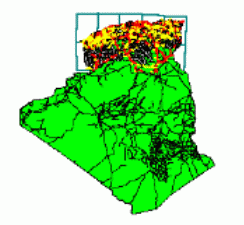
Figure 13. Project Area
The R_ROAD project mainly deals with the definition of a database constituted of different layers and their disposition relatively to a unique reference to assure an homogeneity and a perfect integrity of data.
Moreover, it is important to point out that the scheme project puts an emphasis on the implementation of the structure of a database including the whole main road network of the northern part of the country. This network is made up of roads that are main or secondary links.
The modelling and the interdependence of data have been dealt with in a precise and exhaustive way for the whole set of topics in order to secure an extensive use of the system.
The information collected from potential users clearly identify a need for numeric data and an urgent need for solutions to problems dealing with this kind of data for the whole country.
These data must be updated later, while preserving or improving as possible the data initial accuracy, relatively to the required applications.