Katarzyna Bojarska, Zbigniew Bzowski, Andrzej Dawidowski
Central Mining Institute
Department of Environmental Monitoring
Pl. Gwarkow 1, 40-166 Katowice, Poland
E - mail: scxkb@gig.katowice.pl, scxzb@gig.katowice.pl, scxad@gig.katowice.pl
A spatial interpretation of the results of investigating the occurrence of heavy metal contamination of the soils in post-industrial areas is presented in the paper. From the examined concentrations of barium, cobalt, chromium, copper, manganese, nickel, lead and zinc contents in the collected soil samples, zinc, nickel and lead were selected for presentation. The test results obtained were utilised in creating the project realised with the use of INTERGRAPH Microstation software packag.
In the areas of intensive economic exploitation, such as industrial-mining areas, the humans have become one of the greatest morphogenic factors, which currently decide on the development of the land relief. The speed and size of anthropogenic transformations of this relief are incomparably higher than the transformations caused by natural factors.
The industrial and post-industrial areas of the Upper Silesia region are characterised by two groups of grounds. On the surface there are grounds with the very diversified lithological structure, and physico-chemical properties and soil conditions. Most of them are industrial waste lands, waste rock dumps made of mudstones and carboniferous sandstones, internal dumps of building waste composed of clay from excavations and crashed building materials. The other group are the grounds of native origin, non-managed and devastated in consequence of the industrial performance. These are mainly silty and sandy clays with building refuse added.
The Central Mining Institute's Environmental Monitoring Department has been conducted the investigations on the occurrence of contaminants in the post-industrial areas of the city of Siemianowice Śląskie. This area, subject to many years' industrial anthropopressure, is located in the south-east part of the city, in the neighbourhood of operating industrial plants.
The area is built of the Carboniferous and Quaternary formations. The rocks belonging to the Carboniferous period are represented by shale clay, mudstones and sandstones with coal seams. On the eroded surface of the Upper-Carboniferous claystone-sandstone formations, Quaternary deposits are placed, formed in the shape of sands and glacial gravels, water-glacial and sandy eluvites and silty clays [Bojkowski, Porzycki 1983].
From the archival data it follows that in the considered area, mining was conducted in the past of shallow coal seams by means of small surface mines. In the years 1874 - 1882, a little deeper (20-25 m) seam was also mined. This area and adjacent ones, in accordance with the decision of Regional Mine Supervision Office, was counted, in 1987, into category II of mining damage area. In accordance with the land development plan, the considered area is industrially used. An important element in the structure of the discussed area were the storage areas of raw materials, concrete shapes and access roads to all structures and squares.
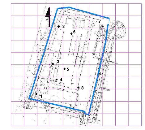
The samples of soils and grounds were collected from 8 probing profiles, in accordance with the methodology included in the literature [Rupm, Krist 1988, Namiesnik at.el., 1995, Bzowski at el., 2001]. The probing was carried out with the use of the HM 1400 Makita impact hammer. To carry out probing in the surface-adjacent layer, the 100 mm - diameter tester was used, and then those with diameters of 75 and 50 mm. To perform analyses, 8 samples were taken coming from surface-adjacent sections of probing profiles (10-30 cm), and 6 soil samples from deeper levels (ca. 3-4 m). The layout of sample collection points is given in Fig. 1.
Fig. 1. Layout of soil samples collection points
The results of heavy metal contents in the soil samples of surface-adjacent profile sections are collected in Table 1, while those for the soils taken from deeper levels are presented in Table 2.
No | 1/1 | 2/1 | 3/1 | 4/1 | 5/1 | 6/1 | 7/1 | 8/1 |
Ba | 210 | 45 | 680 | 65 | 275 | 420 | 145 | 385 |
Co | 12 | 3 | 8 | 2 | 6 | 7 | 10 | 9 |
Cr | 18 | 8 | 155 | 10 | 32 | 22 | 34 | 60 |
Cu | 15 | 8 | 36 | 8 | 42 | 56 | 20 | 78 |
Mn | 990 | 30 | 1870 | 82 | 575 | 458 | 365 | 560 |
Ni | 11 | 3 | 28 | 5 | 14 | 15 | 15 | 36 |
Pb | 66 | 17 | 118 | 20 | 265 | 290 | 36 | 454 |
Zn | 260 | 68 | 475 | 78 | 1230 | 1206 | 142 | 1820 |
Table 1 Heavy metal contents in the samples of soils collected from a post-industrial area in the city of Siemianowicach Śl. [mg/kg (ppm) d.m.]
No | 1/1 | 2/2 | 3/2 | 4/2 | 6/2 | 7/2 |
Ba | 287 | 83 | 356 | 146 | 64 | 70 |
Co | 5 | < 1 | 5 | 3 | < 1 | 8 |
Cr | 32 | 30 | 88 | 16 | 12 | 26 |
Cu | 28 | 14 | 32 | 10 | 12 | 17 |
Mn | 385 | 182 | 456 | 50 | 82 | 110 |
Ni | 20 | 12 | 26 | 30 | 6 | 10 |
Pb | 25 | 6 | 82 | 20 | 67 | 12 |
Zn | 73 | 68 | 320 | 144 | 270 | 86 |
Table 2 Heavy metal contents in the samples of soils collected from a post-industrial area in the city of Siemianowicach Śl. [mg/kg (ppm) d.m.]
The test results obtained were utilised for creating the project realised with the use of INTERGRAPH Microstation MGE software package which includes the following modules in the Windows 95 system:
in conjunction with a Centura SQL database functioning in the Novell 4.11 platform.
The raster was recorded in the system by assigning the coordinate values of 8 control points. Then a local coordinate system was defined, connected with the orthogonal-square grid of measuring points. At the same time, the structure of the database was prepared in accordance with the information data (coordinates x, y; contaminant).
In the course of creating the project from the Microstation MGE level, the authors have designed scripts in the SQL - Century language.
By using the Terrain Analyst module, on the basis of the data collected in the project base, both three-dimensional triangle (TIN) and rectangular (GRID) models were created. To generate the diagrams presented below, the most accurate available interpolation MGE "bicubic" was used.
The creation of interpolation models, to the highest extent possible representing the values of contamination of grounds with the elements, needed to apply the coefficients (constant for each of the elements), that eliminate the effect of the dynamics of the values of data on the visualisation of the phenomenon .
The spatial variability of the contents of zinc, nickel and lead in the examined ground samples are shown in Figs. 2 - 4.
By analysing the presented figures, it is possible to say, that in the NE-SW sections, a distinctly lower contamination with heavy metals is present. In the periphery of the examined area, the contamination due to metals, both at the surface (in soils) and at the depths (in grounds) is distinctly higher. These relationships can be most clearly observed for the samples collected from the surface-adjacent layer of the area. On the other hand, by reason of a small number of samples collected, and their distribution, the heavy metals distribution can be adequately illustrated with the proposed model, only to the north from the NE-SW profile line.

Fig. 2 Spatial variability of zinc content in the examined surface adjacent samples (a), and in deeper probing profiles in the discussed area (b)
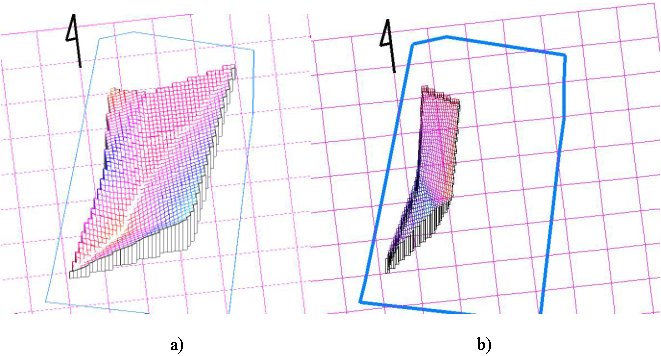
Fig. 3 Spatial variability of zinc content in the examined surface adjacent samples (a), and in deeper probing profiles in the discussed area (b)
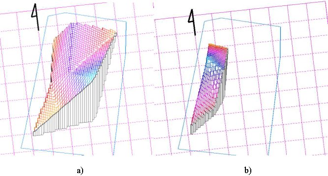
Fig. 4 Spatial variability of zinc content in the examined surface adjacent samples (a), and in deeper probing profiles in the discussed area (b)
The application of the model constructed with the use of the INTERGRAPH Microstation MGE software package to evaluate the occurrence of contaminants in the post-industrial areas makes it possible to visualise the results of investigations conducted. Also, it considerably facilitates the process of data processing, by offering additional examination capabilities. The tool used correctly illustrates the characteristics of occurrence of contaminants in the examined area.
Researches of heavy metals occurrence variability in the examined area permits to perform the evaluation of the contamination condition of this area. This is needed while deciding about the way of reclamation that results from the direction of utilisation.
It is also possible to modify the model, relying on introducing the quantities of immission of pollutants from the atmosphere, to include its influence on the geochemical process in the surface-adjacent soil layers.