Amar Dif1, Tewfik Mostefaoui1,
Samia Zaitra2, Moulay Idriss Hassani2
1 Centre National des Techniques Spatiales (CNTS),
BP 13 Arzew, 31200 Oran, ALGERIE
E - mail: adif@usa.com
2 Université d'Oran Es-Senia (IST)
The physical environment depends on different factors that are essentially the climate, the ground caracteristics and basement, the land cover and the morphometry (surface, shape in the plane, reliefs, hydrographic channel, etc.).
The classical methods used in the watershed survey used are essentially manual, long and tedious technics. These last years, with the development of the geographical process information software like Mapinfo, it became possible to use a declarative language such as SQL (Structural Query Language) able to manage better our data bases and to formulate geographical requests.
Our work has essentially been based on the questioning of the tables (relations) and the results are expressed under different shapes ( table, graphic and map).
The extraction of the indices and hydromorphometric parameters of a wathershed constitute the primary step in all hydrologic survey and their automation should generate the efforts and less costs and a considerable gain of time.
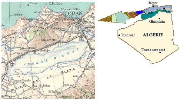
The region of survey is situated in the external zone of the tellien domain. It is implanted between two sets of moutains, the mounts of Tessala to the south, culminating to 1061 meters (pick of Tessala) and the mounts of the Murdjadjo to the North, culminating to 584 meters to Mesabih. These two sets form between them, the big endoréique basin named the watershed of the big sebkha of Oran. The sebkha is constituted of a big extended salt lake, surrounded by a set of plains juxtaposed to the north (plain of Misserghin, Amria, Bou-Tlelis, etc.) and to the south a very big extended plain (plain Meleta).
Geographically, the zone of experimentation is localited between the meridians (0° 45 (and 0° 55 (W) and the parallels (35° 20 (and 35° 30 (N). Fig n°1
Fig n° 1: geographical Situation
To achieve this work only the hydrographic data and the limits of the watershed were used.
The hydrographic channel has been the corrected and updatings by using the satellitales images Thematic Maper of March 17, 1993. This channel is classified and according by STRAHLER classification method as sometimes assigned to SCHUMM. This method is based on the following principle: Fig n°2

Fig n° 2: hydrographic channel and limits of the watershed.
The topographic data combination and satellitales images permitted us to determine eleven (11) sub-watershed draining the plain of the Meleta.
The technic used in the extraction of the parameters and indices hydromorphometric rests on the questioning of the data basis by a set of geographical requests.
These requests, have been formalized by a SQL language computer used under MapInfo.
The results are represented under different shapes (table, graphics and map) Fig n°3.

Fig n° 3: flow map adopted in the extraction of the hydromorphometric parameters.
The use of different types of parameters and hydromorphometric indices have as result the quantification of the characteristic factors of the physical environment of a watershed, which the mains are:

Table 1: perimeter and surface of the watrsheds
This coefficient, found by GRAVELIUS, is the report between the perimeter of the catchment area and the circumference of the circle having the same surface as the catchment area.
Kc = 0.28 * P/S1/2
P: perimeter of watershed (Km)
S: surface of watershed (Km2)
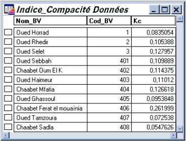
Table 2: indice of compacity of the watersheds
It is purely geometrical transformation under the terms of which one compares the watershed to a rectangle having the same perimeter and the same surface. Dimensions of the rectangle are obtained as follows:
L = [P/2 + (P2/4-4 * S)1/2]/2
l = [P/2 - (P2/4-4 * S)1/2]/2
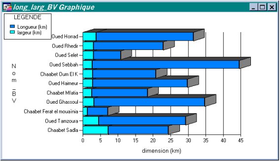
Fig n° 4: graphic representation of the equivalent rectangle dimension
It's the quotient of the number of thalwegs order (x) by that of thalwegs order (x+1).
Rc = Nx / Nx+1
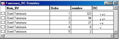
Table 3: confluence report of the watersheds
It is given by the quotient average length of thalwegs order(x+1)by that of the thalwegs order (X).
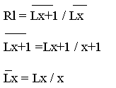
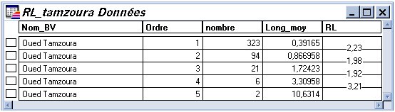
Table 4: length report of the watersheds
It is the report between total length (L) of telweg and the surface of the catchment area (S).
Dd = sommeni = 1 Lx / S
X : main talweg order
N : accumulated length (Km)
S : surface of the watershed (Km2)
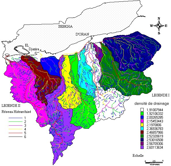
Fig. n° 5 : Map of the drainage density.
It's the report of the number of thalwegs order (x) by that on the surface of the catchment area.
F = N / S (Km-2)
N : Number of talwegs of order (x)
S : Surface of the watershed (km2)
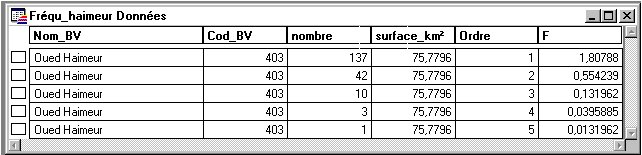
Table 5: frequence of telwegs of the watersheds
It's the report of the number of thalwegs order one (1) by that of the surface of the catchment area.
F1 = N1 / S (Km-2)
N1 : Number of talwegs of order 1
S : Surface of the waterched (km2)
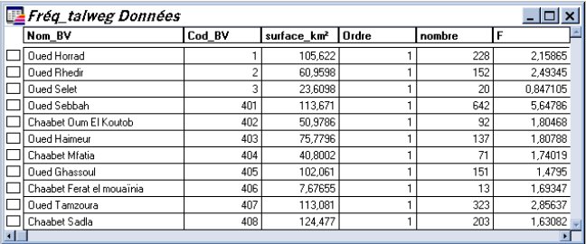
Table 6: frequence of talweg of order 1
CT = DD * F1 (KM/KM4)
F1: Frequence of the talwegs order(1) (km2)
Dd : Density of drainage (Km/Km2)
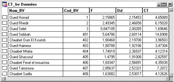
Table 7: coefficient of torrentiality of the watersheds
The automatic extraction of the parameters hydromorphometric of a watershed offers a gain in time and effort.
The results obtained, reveal the capacity and the power of the SQL language in the extraction of the geographical information.
The future use of the SQL language in the domains of the modelling and the cartography hydrologic is essential and open promising perspectives.