E - mail: Ahmed Zine Eddine Saad
Centre National des Techniques Spatiales
Laboratoire de Télédétection
B.p 13, 01 Avenue de la Palestine
Arzew 31200, Oran, Algérie
Fax: 0021341473665
E - mail: a_z_saad@yahoo.fr
The methodological progresses as for the performances of remote sensing have generated a multivarious analysis which became operational thanks to the of geographic information system, and to the possibilities of crossing geologic and geophysics data and remote sensing. Indeed, technically, the encrustation, the superposition, the processing of multisources images and the remote sensing data between them or with other geologic variables, is made easy by the development of the geographic information system which is conditioned by a data base. This data base previously established permits to raise the request that we want to bring fore ward. It contains the geologic information and those geophysics in the occurrence the radioactive values of uranium, thorium and potassium 40. Our study area which belongs to the central hoggar polycyclic (southern Algeria), is presented by two differents domains: the precambrian basement and the sedimentary cover. These two domains are separated by an abnormal contact. The precambrian basement and the sedimentary cover are presented respectively by the middle proterozoic, the devonian and the cambro-ordovician. So the aim of this type of analysis is to optimise the thematic interest searched for with the help of the different geologic, geophysics layers crossing them in a simultaneous way. The final result is presented by a thematic map on which we can identify the uranium area.
Keywords: multivarious analysis, data base, radioactive values, central hoggar, polycyclic, uranium area.
The advent of the systems of geographical information in the domain of geology is fundamental.Apart from its design, it sets up a data base which allows us to manage better our geological informations, i.e, the lithologic nature , the fracturation and the mineralisation.
The management of these geological informations goes through a crossing or superposition of these data. The multivarious analysis via a request accredits this crossing. The final result of this operation is thematic.
The aimed objective consists of characterizing in a synoptic manner all the uranium and thorium anomales zones present in precambrien socle and in the sedimentary cover. This objective is conditioned by a data base which is established initially and which is fundamental for one request. The last one is previously specified. It is done using the structured query language (S.Q.L).
The region of study belongs to the leaf of Asseo. It is limited North and South by the latitudes 22°30' N and 20°30'N. For the west and the east, the longitudes are 6°30'E and 8°E.
Two domains belonging to the central Hoggar polycyclic different by their mode of outcrop and their lithologic composition come to characterize the geology of the zone of In Azzaoua: a crystallin precambrien socle formed by some formations dated lower Proterozoic (Pr1), and middle Proterozoic (Pr2), composed generally by the metasediments-gneiss and of a syn orogenic granite (g4) essentially red to biotites. Then of a sedimentary cover tabular and discordant on this socle, which is composed by some geological outcrops of grey and argilo grey nature dated Paleozoic (devonian unit).
Example for number of anomal point (P) | Layer (age) | Lithology | Priviliged directions | spectroradiometric values Th. Ur. K. 40 | U/TH | U/K40 | ||
2 | devonian | standstone | N 50°-70° | 10 | 33 | 56 | 3,30 | 0,59 |
129 | Lower proterozoic (Pr1) | meta-sédiment | N 10°-30° | 20 | 22 | 65 | 1,10 | 0,34 |
161 | syn-orogenic ((4) Granite | red granite of biotites | N 350°-10° | 30 | 61 | 77 | 2,03 | 0,79 |
222 | syn-orogenic ((4) Granite | red granite of biotites | N 350°-10° | 32 | 59 | 89 | 1,84 | 0,66 |
241 | middle proterozoic (Pr2) | gneiss of biotite-garnet and disthene | N 350°-10° | 30 | 28 | 108 | 0,93 | 0,26 |
Table 1. Example of the structure of the geological and geophysical data base of the zone of In Azzaoua. Leaf of ASSEO (Central Hoggar Polycyclic).
The most important steps of this study are the set up of the data base. The information collected in our study are structured in table 1. They are in a geological, a lithological and a geophysical order.
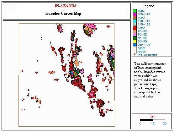
The geophysical data introduced in this data base correspond to a map of the isorades, at the scale of 1/ 200.000 with a equidistance of fifty shocks per second (50cps) and of which their airborne values are acquired at an altitude of 150 meters (figure 1), this is on one hand.
Figure 1 Representation of the different isorades curves and distribution of the different anomals points of the radioactive elements of a part of the zone to a larger scale
On the other hand, they include also the spectroradiometric values of each anomal point (p) which is symbolized by a triangle. Those values are respectively of thorium, uranium and potassium 40. Figure 2 represents as for , the different isorades curves as well as the distribution of the different anomals points of the radioactive elements of one area of the zone of study with her faults but at a larger scale.
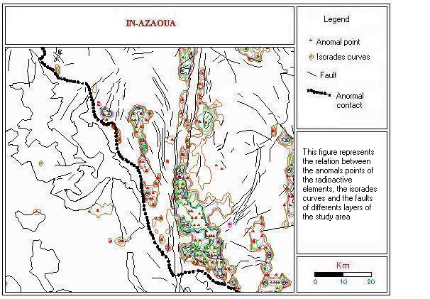
Figure 2. The relations map between the anomals points, the isorades curves and the different layers of the study area.
The multivariuos analysis allows to realize several requests. A request consists of defining a geological homogeneous class of the crystalline socle or the sedimentary cover, and supposes an operation of crossing (simultaneous integration) its differents attributes that we want to manage.
This request is managed by structured query language (S.Q.L.) which is a language of data base interrogation. This request is of selective nature. It starts by the selection of a layer (layer to search) then by posing the condition (search condition) of our objective. The result of this request would be the visual superposition the attributes which are chosen in advance of the selected class. It consists to define all the uranium anomals zones by the operation of relationship of the spectroradiometric values of the U/TH as their ratio is superior or equal to 1. The result of these relationships is presented in figure 3.
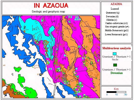
Figure 3. Characterization of the uranium anomals zones through a multivarious analysis.
The objective of this study is to show from a thematic point of view and in a synoptic manner, all the anomales zones present the précambrien socle and in the sedimentary cover and principally the uranium zones. This will be made through a request which is based on the multivarious analysis.
This request is managed a language of interrogation of a data base (structured query language). This analysis is privileged by the data base previously defined. It allowed to disengage to an instant (t) the synoptic position of all the existing anomales zones.
Figure 3 shows the result of the condition of the ratio of the attributes U / TH (ratio of the spectroradiométric values of the uranium / the thorium) as for this last is superior to 1. The results of this last one are represented by the squares of hues blues as for its behaved to the crystalline socle and the squares of green hues as for the cover sedimentary grey.
We conclude that the multivarious analysis allowed us, first, to make an analysis of the whole distribution of the uranium mineralization in our study, by the visual synoptic result that it offers. This permitted us on one hand, to make an analysis on the distribution of these uranium areas uraniferes on the whole zone. And on the other hand, to make the correlation between these mineralized sectors, and see the influence of the fracturation which affects them while taking into account lithologic of the facies nature and of its dating.