
Marketing Communications Manager
EuroGeographics
Tel: +33 1 64153278
Fax: +33 1 64153219
haico.vegt@eurogeographics.org
Europe is expanding. In the coming years, the European Union will be extended with another 10 countries. These changes more and more stress the need for consistent geographic information (GI), looking across national borders, that can support successful policy making, contribute to better governance and improve services to the citizen.
EuroGeographics as an organisation has also grown. From being an association with its membership coming from the National Mapping Agencies, it has now developed to an organisation which encompasses the Cadastral and Land Administration organisations as well.
We can trace back the origins of EuroGeographics as an organisation more than 20 year, when Europe's NMAs first came together to share, discuss and resolve common problems. They founded CERCO, Comité Européen des Responsables de la Cartographie Officielle.
In 1993 they established a subsidiary, MEGRIN (Multi-purpose European Ground Related Information Network), which managed pan-European projects including the development of web-based metadata services and integrated geographic databases.
It soon became clear that merging MERGIN and CERCO would improve communications, team-working and efficiency. So, in Malmö (Sweden) September 2000, EuroGeographics was established to fulfil the roles of both these organisations. Today, EuroGeographics consists of 43 members from 40 countries.
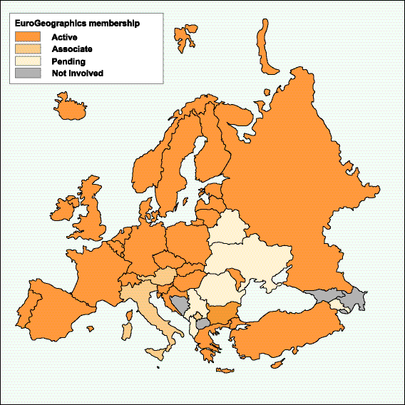
Figure 1: EuroGeographics membership October 2003
The benefits for every member are obvious. It provides a forum for best practice in pricing and licensing issues, data quality management, geodesy and other day-to-day issues that face every member. EuroGeographics acts as lobbyist and central point of contact towards the European legislation and the GI industry. And by harmonising and making datasets interoperable, the market and revenues for national products will grow. Lastly, EuroGeographics acts as the promoter of Geographical Information in general within Europe, especially towards the European Commission and the GI industry. Stressing the importance of high quality, definitive spatial data for the public and private sector and the (European) citizen works for the good of every member.
Our mission is to represent Europe's National Mapping and Cadastral Agencies. It is in this role that we want to stimulate increased cooperation between our members across Europe to realise our vision: "Achieve interoperability of European mapping and other GI data within 10 years", making national databases interoperable and more widely available within Europe, contributing to build a European spatial data infrastructure. An infrastructure that does not only include defining the technical specifications for spatial datasets, but also the pricing and licensing conditions for using the data, the metadata to find it and the organisational framework behind it, in short, implementing the principles of an INfrastructure for SPatial InfoRmation in Europe (INSPIRE).
EuroGeographics is an association with an annual budget of around € 700,000 and led by seven management board members, elected during the General Assembly, an annual meeting of all Director Generals of the NMCAs. Joakim Ollén (Sweden) has been President till October 2003. He has been followed by Dietmar Grünreich (Germany), our current President.

Figure 2: Mr. Dietmar Grünreich, President of EuroGeographics
The permanent staff (at the moment 5) of EuroGeographics makes up our head office, under the management of the Executive Director, Nick Land. Team members within the head office are generally seconded from the staff of member NMCAs and provide both technical and marketing skills. It is this team that coordinates EuroGeographics' various projects and expert groups.
However, most of EuroGeographics' work is distributed to our members to make use of their expertise, resources and experience. The management of the main projects, as well as the chairmanship of expert groups, are delegated to some of EuroGeographics members while each member participates on a voluntary basis in activities that are of interest.
Our products and projects are developed using three approaches - project teams, expert groups and third party partnerships.
Our virtual projects teams are multinational teams responsible for developing our products. They work from their home base, but are coordinated by project managers from within the membership. At the moment, EuroGeographics covers seven project teams:
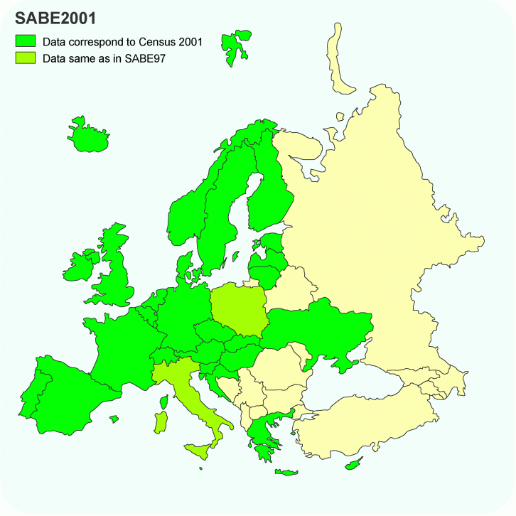
Figure 3: SABE 2001 coverage
By bringing together experts from the NMCAs we currently have three specialist teams that we call expert groups, providing a forum for exchanging best practice and discussing the day-to-day issues facing all our members:
We also recognise the importance of working with other to develop the ESDI and therefore we have established partnerships with the European Commission, Value Added Resellers and a number of leading pan-European and global GI organisations, like WPLA, EUROGI, EuroSDR and GSDI.
One of the main concepts is that mapping and cadastral data, the so called geographic reference data, are the key to build an ESDI successfully, by creating efficient processes to establish and maintain reference data at a European level. Looking from this European perspective, the INSPIRE initiative, launched by the European Commission in 2001, has given much push to the concepts of a common reference data framework.
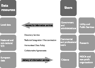
Figure 4: schematic of Europe’s spatial data infrastructure
To realise the full potential of INSPIRE and make cross border spatial data interoperable and available, there are a number of obstacles to overcome. These include the availability of pan-European products harmonised to agreed standards and access to better metadata about the available products. However, it is also recognised that it is the 'organisational' rather than 'technical' barriers that present the biggest problems. Particularly, the diversity of pricing and licensing rules across Europe creates major obstacles for easy data exploitation.
EuroGeographics is very much engaged the next few years to overcome these barriers by developing solutions to improve the access to spatial data in Europe. A number of projects have been initiated to address these barriers of borderless and interoperable reference data.
EuroSpec
The implementation of EuroGeographics' core vision goes hand in hand with the steps envisaged by INSPIRE for developing the ESDI for common reference data, like transportation, hydrography, buildings and elevation data. The EuroSpec project has the scope of a programme of work, linking and bringing together almost all EuroGeographics' activities. Having this umbrella function it assists in implementing our vision, by initiating specific projects for the development of the ESDI components.
Pricing & Licensing
As already said it is often the different pricing and licensing arrangements within a country that prohibits easy use of cross border data. To address these barriers, EuroGeographics has initiated the 'Pricing & Licensing' project, to develop best practice guidelines. Starting from the differences between each country, this project aims to develop common terminology, licensing templates and pricing framework for its pan-European products.
Metadata
A metadata catalogue is a prerequisite to identify which data is available where. EuroGeographics has developed its own metadata service - the GDDD - which provides discovery level information about our members' datasets.
At the moment, this metadata service is being upgraded, adopting the ISO standard and available on-line in the beginning of 2004 as the EuroMapFinder service.
With the European Union growing bigger the coming years, the need for strong collaboration on all aspects of life is obvious. Problems and solutions become more and more European instead of national. We have to look across our national borders on issues like pollution, river management, transport, market planning, etc.
Reliable spatial data is a basic requirement for solving these every day problems. The need for cross-border data, that underpin these problems, is clear. And with the latest extension of EuroGeographics' membership, the organisation as an association has grown stronger in helping to address and solve these every day problems.