Difference between revisions of "Zobrazení prostorových dat v GeoRaptoru"
m |
m (→Tvorba tabulky s bodovými daty) |
||
| Line 35: | Line 35: | ||
CONNECT BY LEVEL <= 500; | CONNECT BY LEVEL <= 500; | ||
COMMIT; | COMMIT; | ||
| + | |||
| + | *Vytvoření metadat k tabulce Point2D | ||
| + | |||
| + | GeoRaptor nabízí tvorbu metadat, která budou uložena do tabulky SDO_GEOM_METADATA. that is required before we can create a spatial index. | ||
| + | |||
| + | [[Image:manageMetadata.png]] | ||
| + | |||
| + | So, to invoke GeoRaptor's metadata created form, right mouse click on the POINT2D table node and select "Manage Metadata" | ||
| + | |||
| + | One of the strengths of GeoRaptor is its ability to create the Oracle SDO_GEOM_METADATA metadata that is required before we can create a spatial index. | ||
| + | |||
| + | So, to invoke GeoRaptor's metadata created form, right mouse click on the POINT2D table node and select "Manage Metadata" | ||
Revision as of 07:51, 24 August 2014
Propojení dat s prostorovou složkou, uložených v Oracle databázi, a vizualizační apliakcí GeoRaptor, umožňuje zobrazit geometrii dat a vybrané atributy v okně prohlížeče.
Na jednoduchém příkladě si ukážeme způsob přípravy jednoduchých prostorových dat typu Point a jejich zobrazení. (Inspirováno popisem ze stránek A Gentle Introduction: Create Table, Metadata Registration, Indexing and Mapping.)
Tvorba tabulky s bodovými daty
- Vytvoříme si novou tabulku, do které vložíme bodová data.
DROP TABLE Point2D;
CREATE TABLE Point2D (
 id           integer,
 label        varchar2(20),
 angleDegrees number,
 rgb          varchar2(20),
 iRGB         integer,
 geom         mdsys.sdo_geometry
);
- Vložíme bodová data do tabulky Point2D níže uvedeným skriptem:
INSERT INTO Point2D (id, label, angleDegrees, rgb, iRgb, geom)
 SELECT rownum,
        CHR(dbms_random.value(65,90)) || to_char(round(dbms_random.value(0,1000),0),'FM9999') as label,
        ROUND(dbms_random.value(0,359.9),1) as angleDegrees,
        ROUND(dbms_random.value(0,255),0) || ',' || ROUND(dbms_random.value(0,255),0) || ',' || ROUND(dbms_random.value(0,255),0) as rgb,
        power(2,16)* ROUND(dbms_random.value(0,255),0) +
        power(2,8) * ROUND(dbms_random.value(0,255),0) +
                     ROUND(dbms_random.value(0,255),0) as irgb,
        mdsys.sdo_geometry(2001,NULL,
              MDSYS.SDO_POINT_TYPE(
                    ROUND(dbms_random.value(358880  - ( 10000 / 2 ),
                                            358880  + ( 10000 / 2 )),2),
                    ROUND(dbms_random.value(5407473 - (  5000 / 2 ),
                                            5407473 + (  5000 / 2 )),2),
                    NULL),
              NULL,NULL)
  FROM DUAL
CONNECT BY LEVEL <= 500;
COMMIT;
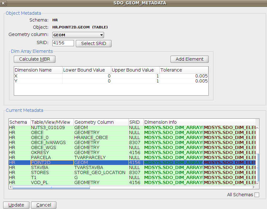
- Vytvoření metadat k tabulce Point2D
GeoRaptor nabízí tvorbu metadat, která budou uložena do tabulky SDO_GEOM_METADATA. that is required before we can create a spatial index.
So, to invoke GeoRaptor's metadata created form, right mouse click on the POINT2D table node and select "Manage Metadata"
One of the strengths of GeoRaptor is its ability to create the Oracle SDO_GEOM_METADATA metadata that is required before we can create a spatial index.
So, to invoke GeoRaptor's metadata created form, right mouse click on the POINT2D table node and select "Manage Metadata"
