Symposium
GIS Ostrava 2010
25th - 27th
January 2010 
Menu


Résumé
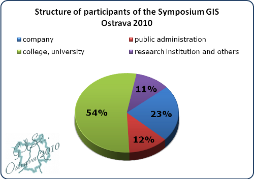
17th International Symposium GIS Ostrava took place on 24th – 27th January 2010 at the VŠB – Technical University of Ostrava. The subtitle of this year – "GIS with remote sensing and photogrammetry towards a digital world" – reflects the advances in earth observation technologies in the last period. The symposium was organized by the Institute of Geoinformatics in coordination with the Czech Association for Geoinformation (CAGI), Slovak associations for geoinformatics (SAGI) and the Internatinal Society for Photogrammetry and Remote Sensing (ISPRS). Symposium was held under auspices of the Rector VSB – Technical University of Ostrava prof. Ing. Tomas Cermak, CSc., Dean of the Faculty of Mining and Geology VSB – TU prof. Ing. Vladimír Slivka, CSc., Dr.h.c. and the president of the Moravian–Silesian Region Ing. Jaroslav Palas. The New Hall of VSB – Technical University of Ostrava offered a decent space for meetings of 268 registered participants of the symposium. Participants of this symposium came from 14 countries including the Czech Republic, Slovakia, Poland, Spain, Germany, Hungary, Russia, Italy, Egypt, Finland, Sweden, Switzerland, Austria and Great Britain. More than half participants represent a tertiary sector (universities, colleges), followed by commercial sector, public administration and research institutions.
Pre–conference part of the programme in Czech language began on Sunday. Three interesting seminars took place during this first day – seminar about the WFS and WMS in Open Source, LIDAR data processing and the most favourite seminar about hydrological and environmental modelling. In particular, the capacity of the last mentioned workshop was unable to meet the demand of candidates. Monday morning started again with the seminar entitled "Hydrological and environmental modelling using GIS" and corporate workshop of T–MAPY.
Opening Ceremony with the participation of the Rector of VSB–Technical University of Ostrava prof. Tomas Cermak started a major part of the symposium. There were presented three key contributions in the initial block. Dr. Zbynek Malenovský from the University of Zurich prepared a contribution Imaging Spectroscopy of Vegetation Photosynthetic Activity. Dr. Eva Kubátová from the Ministry of the Interior of the Czech Republic announced a new policy of the state in the field of spatial data. Prof. Anders Östman, from the Swedish University of Gävle, presented an interesting paper entitled Network for GI testing services.
After the initial block Symposium programme was divided in two, on Tuesday in three, parallel sections, after the initial block. Symposium programme included 41 papers in the application block in the Czech language and 55 papers in reviewed research block in the English language. Given the subtitle of this year's symposium, the most represented section was Photogrammetry and Remote Sensing in the research block. On the other hand, section about GIS and spatial data in public administration and the issue of the use of GIS in water management were the most represented sections in the application block. It seems that these topics are very current and discussed. The programme was supplemented by the corporate contributions of the companies Geodis Brno, GEFOS, INTERGRAPH CS and ARCDATA PRAHA. Prof. Gottfried Konecny, Professor Emeritus of the University of Hannover, presented an interesting contribution about his experiences at the University of Nairobi.
The poster session is also an integral part of the symposium. There were presented 16 posters, which were included in the competition. The prize was certificate on a luxury bus service in Europe from Student Agency and a gift from the portal Geoinformatika.sk. Like last year, it was possible to vote via the internet portal. The winner was a poster entitled "Modelling of Erosion–sedimentation Processes Caused by Extreme Hydro–meteorological Situations Using GIS" by authors Boris Šír, Jozef Richnavský and Peter Bobal (results can be seen on the portal Geoinformatika.sk). From the voting participants were drawn the second owner of the certificate from the STUDENT AGENCY, the winner became Lucie Kondrová.
Based on great interest in the last year, there was included an excursion to the National Transport Information and Control Center (NDIC) during the Tuesday's programme. NDIC was opened in Ostrava 11th September 2008 and its founder and operator is the Road and Motorway Directorate of CR.
Last day of the symposium participants had the opportunity to visit the workshop of ARCDATA PRAGUE related to the introduction of new product options in ArcGIS and ENVI. In the afternoon, the seminar about Tips and tricks for a Nice Visual Map Using ArcGIS Desktop 9.3 was prepared by the guarantor Dr. David Vojtek, also with a great demand.
During the symposium, seminar VESTA–GIS was held; it was focused on lifelong learning in the field of GIS, whose principal aim was to inform about the ongoing European project VESTA–GIS, information about the possibilities of its use and discuss the status of vocational and lifelong learning in the field of GIS in the Czech and Slovak Republic. In the seminar programme gave a speech prof. Anders Östman that introduced the project itself as well as some examples of training modules in Gävle, Berlin and Dublin. In another programme, representatives from among academics and representatives of companies discussed and presented their views on the lifelong education and especially training in this field. On the end of the seminar it was discussed issue of current professional status (professional) education in the field of GIS, the role of universities, companies and other institutions (eg. CAGI, SAGI) in this process, benefits of the project VESTA–GIS. Discussion was also focused on question what is the most missing thing to improve and streamline the state of vocational education.
The symposium is not only about results presentations, but also about obtaining new ideas, getting contacts and informal meetings with experts from various fields and institutions. So there were arranged two social evenings. The first one took place in the foyer of the New Hall VSB–TU and was dulcifying by music of the dulcimer music band Lipka. The other one was held at the Observatory and Planetarium of J. Palisa, where the participants saw the program Hidden Beauty of the Universe, and with the assistance of demonstrators they had the opportunity to observe the starry sky.
Nowadays, it must be said that it would be very difficult to hold the symposium without massive support of sponsors and media partners, which were Gefos – complete services in surveying and photogrammetry and dealerships Leica Geosystems, DIGIS, ARCDATA PRAHA, T–MAPY, INTERGRAPH CS, STUDENT AGENCY, Geodis and Taylor & Francis. Media partners were GeoBusiness, Geoinformatika.sk and GPortál. We want to thank them for their support.
We want to thank to all the symposium participants, who found the time and arrived at the annual meeting to Ostrava, despite this year's extreme winter conditions. We believe that each of you took something new from the symposium either in the form of new ideas, visions or new contacts.
We are looking forward to see you at the next symposium.
Programme Committee of the Symposium GIS Ostrava 2010
Assoc. Prof. Jiri Horak
Organizational Committee of the Symposium GIS Ostrava 2010
Lucie Hrubá